
- Digital Yacht
Username or email address *
Password *
Lost your password? Remember me

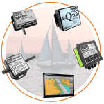
NAVIGATION SENSORS

Which navigation sensor?
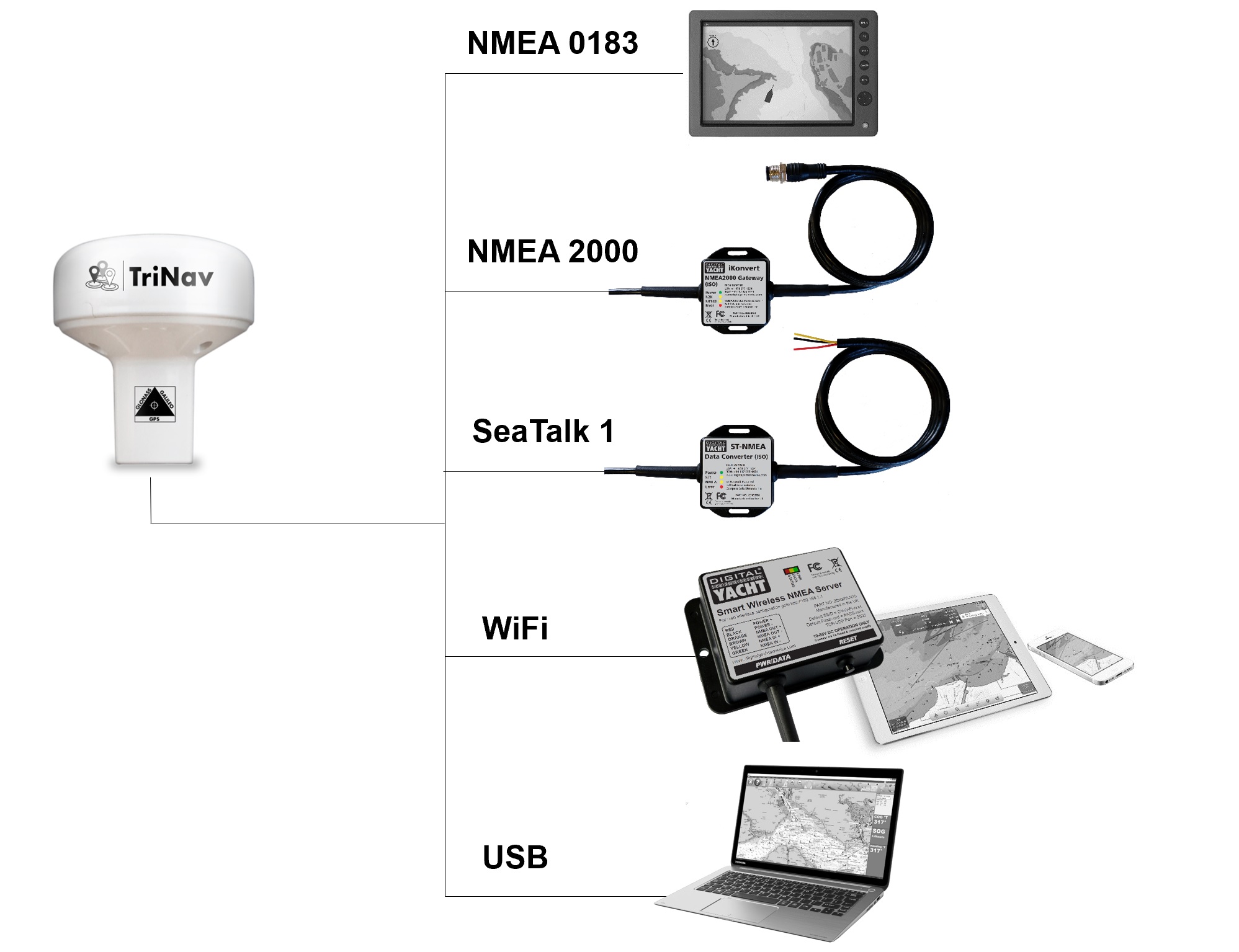
Digital Yacht offer a range of primary instrument sensors including position (GNSS), compass heading, wind and speed/depth. Our sensors are easy to install and all have industry standard NMEA outputs allowing connectivity with a wide variety of systems and products.
Our NMEA converter, NMEA to WiFi and SeaTalk Gateway products allow data exchange between other data formats too including NMEA 2000, USB, SeaTalk1 and WiFi for tablet connectivity.

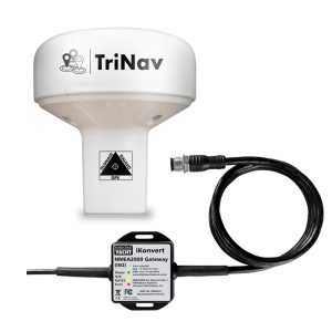
TriNav offers unprecedented value for money and accuracy and takes advantage of compatibility with GPS, Glonass and the new Galileo satellite systems.
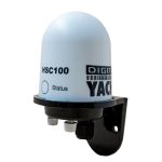
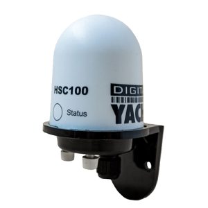
Is an accurate fluxgate compass heading data and remains a fundamental parameter for marine navigation. The HSC100 uses fluxgate technology to deliver heading data for on board systems.

Is a wind sensor with NMEA interface and it features an ultra tough design with UV and salt resistant.

Smart Sensor
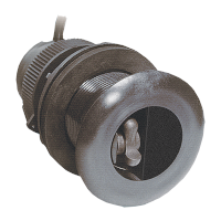
Is a depth, speed, and temperature multi-sensor with an NMEA interface. Signals are processed inside the sensor and can be displayed on any radar, chart plotter, or device that accepts NMEA data.
How to integrate the sensors together?
With our NMEA interfaces and multiplexers, our navigation sensors can easily be integrated. We have different packs/solutions for our range of instrumentation sensors which now includes GPS, depth, speed, wind and compass. These can now be integrated into NMEA0183 and NMEA2000 systems and provide a complete on board solution with tablet and PC connectivity too.
Contact us and tell us your requirements and we will tell you exactly what you need but here are some solutions:
It is a range of complete marine instrumentation packs based on NMEA 2000 and wireless connectivity – allowing for maximum flexibility and connectivity. Choose from using phones, iPads and tablets for boat data displays as well as 3rd party industry standard instruments and multi function displays.
Top quality and highly accurate sensors are used for boat depth, speed, wind, compass and GPS data.

Advanced iSeaSense Pack
A sophisticated system with a Class B SOTDMA AIS transponder integrated to provide AIS and GPS data as well as instrumentation.
This system is expandable using a NMEA2000 backbone and the iSeaSense Wi-Fi Server stream wirelessly all instruments and AIS data on to navigation apps & software.
Discover our products

Our GPS/Galileo/Glonass positioning sensor.
Fluxgate compass with auto calibration and fast heading output.

Ultra tough wind sensor with NMEA interface.
- Multisensor
Smart Sensor is a depth, speed, and temperature multi-sensor.
- Automatic Identification System (AIS)
- PC on Board
- Portable Navigation
- AIS Receivers
- AIS Transponders
- VHF Splitters & Antennas
- AIS Beacons
- AIS Accessories
- NMEA to WiFi Servers
- NMEA Interfaces
- NMEA 2000 Cables
- SeaTalk Interfaces
- USB Interfaces
- 4G/5G Internet Access
- Hi Power Long Range Wifi
- Accessories
- PC Accessories
- TV Antennas
- PC Software
- Android Apps
- Antenna Mounts
- Connectors + Adaptors
- Instruments
- PC Navigation
- Internet Access
- Get Support
- Product Manuals
- Tech Support Notes
- Product Firmware
- Software and utilities
- USB Drivers
- WLN10 & WLN30
- Products with NMEA2000 interface
- How to configure apps & software?
- Product Registration
- General News & Events
- Product Information
- Applications
- Product Pictures
- Product Guide
- Login / Register
We value your privacy
Privacy overview.

- Digital Yacht
Username or email address *
Password *
- All products
- Multisensor
GPS160 offers unprecedented value for money and accuracy and takes advantage of compatibility with GPS, Glonass and the new Galileo satellite systems.
Typical accuracy is approximately 1m and data can be set for output at up to 18Hz for smoother display on chartplotters.
Showing all 6 results
- Average rating
- Price: low to high
- Price: high to low
Price filter
- 0,00 € - 90,00 €
- 90,00 € - 180,00 €
- 180,00 € - 270,00 €
- 270,00 € +

GPS160 NMEA 0183
“The GPS160, a high performance positioning sensor using GPS, Galileo, Beidou and Glonass satellite systems for exceptional positioning accuracies and redundancies. GPS160 has an NMEA 0183 interface.”
GPS160 NMEA 2000
“GPS160 supplied with iKonvert (NMEA2000-NMEA0183 converter) allowing easy and flexible NMEA 2000 installation.”
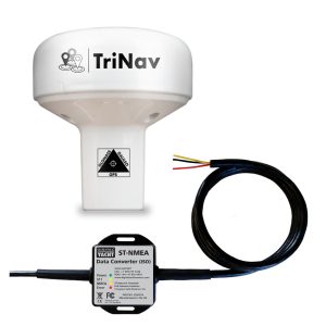
GPS160 SeaTalk
“GPS160 SeaTalk version is supplied with Digital Yacht SeaTalk1 to NMEA0183 converter allowing easy replacement of older Raystar sensors.”

“The GPS160USB variant ships with a 5m USB cable. It’s self powered from the USB source (PC, MAC or Linux).”
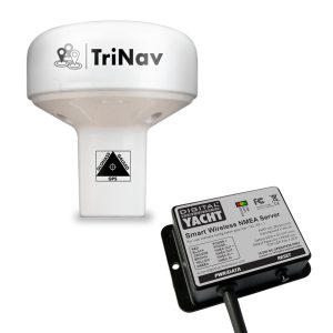
GPS160 Wireless
“The GPS160 wireless GPS antenna version is supplied with Digital Yacht NMEA to WiFi gateway for wireless navigation with tablets and iPads.”

GPS160F with Furuno Data Output
“Digital Yacht have introduced a specific version of the GPS160 which is a simple replacement for older Furuno plotter and GPS systems. “
- Automatic Identification System (AIS)
- Navigation sensors
- Internet on board
- Portable Navigation
- AIS Transponders
- AIS Receivers
- VHF Splitters & Antennas
- AIS Accessories
- NMEA Interfaces
- NMEA to Wi-Fi Servers
- NMEA 2000 Cables
- SeaTalk Interfaces
- USB Converters
- 4G/5G Internet Access
- Hi Power Long Range Wifi
- Accessories
- PC Accessories
- TV Antennas
- PC Software
- Apple & Android apps
- Antenna Mounts
- Connectors + Adapters
- Internet Access
- PC Navigation
- Product Manuals
- Product Firmware
- Technical Notes
- Utilities and tools
- Software and utilities
- USB drivers
- Get Support
- Product Registration
- Product Return Form
- How to configure our AIS
- How to configure our 4G products
- How to create an NMEA 2000 network
- How to configure apps & software
- Technical FAQs
- Products with NMEA 2000 interface
- WLN10/WLN30
- Login / Register

- Digital Yacht
Username or email address *
Password *
Lost your password? Remember me
GPS160 NMEA 0183
£ 156.00
“The GPS160, a high performance positioning sensor using GPS, Galileo, Beidou and Glonass satellite systems for exceptional positioning accuracies and redundancies. GPS160 has an NMEA 0183 interface.”
- Description
- Additional information
- Manual and Downloads
- what inside box
KEY FEATURES
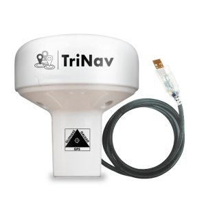
Digital Yacht have unveiled their TriNav™ GPS160, a GPS antenna with NMEA 0183. This is a new, high performance positioning sensor using GPS, Glonass, and the new Galileo satellite systems. Therefore, providing exceptional position accuracy and redundancy. Typical accuracy is better than 1m. Data can also be set to output at up to 18Hz for smoother plotter track displays. TriNav™ software technology also improves positioning inaccuracy that could occur through spoofing and local interference.
The device has a variety of modes through field programming. This includes single GNSS operation (eg Galileo only) as well as output configurations such as update rate, NMEA sentence structure etc.
The GPS160 with NMEA 0183 output (4800, 38400 and 115200 baud programmable). As well as a USB variant for PC, MAC and Linux. For NMEA 2000 systems, we offer a bundle with a Digital Yacht iKonvert NMEA 2000 gateway. Therefore allowing the easy and flexible install of NMEA 2000 without the need for cumbersome drop cables.
The GPS160 also supports a simple external MOB (man-over-board) switch or device. When triggered, the GPS160 creates a “synthesised” AIS SART MOB message on its NMEA output. This can then interface with a local plotter to identify the MOB. Most modern plotters support this with a clear MOB icon. As well as instant bearing and distance data to navigate to the casualty.
To learn how to wire the GPS16o to your navigation system click here
Galileo is the new global navigation satellite system (GNSS) that has been in development over the past two decades. It joins the GPS and GLONASS systems and offers mariners a 3rd reliable positioning source. It is now fully operational as of 2020.
There are currently 22 satellites in usable condition. This means the satellite is working and adds to the service provision. There are then 2 satellites that are in “testing” and 2 more are marked as not available. The final constellation now consists of 30 satellites (24 operational and 6 spares) as of 2020.
October 2023 – New Features: All GPS160 models now feature a new GNSS engine that supports QuadNav technology. These models now support the Chinese Beidou satellites (as well as GPS, Glonas and Galileo), which means all position fixes, course and speed over ground calculations will now be utilising the strongest satellite signals from a network of over 100 satellites. This results in improved time to first fix, more robust operation against jamming, “spoofing” and outages and also improved current consumption (<25mA)
SPECIFICATIONS

- 72 channel GPS, Glonass , Beidou and Galileo GNSS positioning receiver
- Typically sub 1m accuracy thanks to QuadNav™ technology –combines all satellite data for optimum accuracy
- Can be configured as dedicated GPS, Glonass, Beidou or Galileo only device
- Refined anti-spoofing algorithm for robust performance of position and interference rejection
- Available Seatalk1 (with Seatalk converter) , NMEA 2000 (with iKonvert interface) and wireless (with WLN10SM) variants
- GPS160USB also available with USB connection for PC/MAC
- User/field can select 4800, 38400 and 115200 baud operation through simple internal DIP switches
- Many formats of NMEA data output including datum information –user can configure through internal DIP switches
- Up to 18Hz update rate (user can select)
- Ultra low (<20mA) power consumption at 12V DC
- Input for MOB switch/system –when triggered generates synthetic AIS MOB NMEA output to activate MOB position on plotter
- Efficient system (ECDIS) support with datum sentence structure (DTM/GBS/GNS/GRS/GSA/GST)
- Puck installation or fits 3rd party industry standard 1” x 14TPI threaded mount
GPS160 Quick Start Guide V2_00 (sold from 1st October 2023)
Gps160 quick start guide v1.01.
The GPS160 can be operated in a number of different modes, designed to satisfy different installation scenarios and optimise performance with older systems.
Those operating modes can be set by adjusting four DIP switches inside the unit.
To access the DIP switches, it is necessary to open the GPS160.
We have list with wiring diagrams which explains how to connect the GPS160 to popular marine equipment.
You can check the list by clicking here.
If your product is not included in this list, contact us via email.
Yes, with the GPS160 SeaTalk1 version.
Yes, with the GPS160 NMEA 2000 version. It is supplied with the iKonvert (NMEA0183 / NMEA2000 converter).
Yes it has some legacy modes that should work with older NMEA 0183 equipment.
Yes but you need the Furuno Compatible model part# ZDIGGPS160F
Yes, it can be flush mounted.
You may also like…

GPS160 Wireless

GPS160 NMEA 2000

- PC on Board
- Portable Navigation
- Latest products
- AIS Receivers
- AIS Transponders
- VHF Splitters & Antennas
- AIS Beacons
- AIS Accessories
- Multisensor
- NMEA to WiFi adaptors
- NMEA Interfaces
- NMEA 2000 Cables
- SeaTalk Interfaces
- USB Interfaces
- 4G & 5G Internet Access
- Hi Power Long Range Wifi
- Accessories
- PC Accessories
- TV Antennas
- PC Softwares
- Antenna Mounts
- Connectors + Adapters
- Clearance & Ex Demo Offers
- Instruments
- PC Navigation
- Internet Access
- Get Support
- Technical FAQs
- Product Manuals
- Tech Support Notes
- Utilities and Tools
- USB Drivers
- AIS Transponder
- 4G Products
- Apps & software?
- WLN10 & WLN30
- Products with NMEA 2000 interface
- Product Registration
- General News & Events
- Product Information
- Applications
- Product Pictures
- Latest videos
- Product Guide
- Login / Register

We value your privacy
Privacy overview.
- Shopping Cart 0

Digital Yacht Marine GPS Navigation

Digital Yacht’s first time at Båtmässan Allt för sjön 2024

How to configure AIS transponder with web interface?

Digital Yacht partners with Engo ActiveLook Glasses

Digital Yacht at Miami International Boat Show 2024!

Digital Yacht GPS105 (GPS150) is a perfect replacement for Raystar 120 or 125

Please note that this older post has now been updated for our latest GPS150 smart antenna.
With Spring just a few days away and thoughts turning to the new sailing season, we have noticed an above average increase in requests for our GPS150 smart GPS antenna. On further investigation, it would appear that many of these units are being used as replacements for old Raymarine Raystar 120 and 125 GPS antennas.
Although not Seatalk compatible, the GPS150 is a very good and cost effective replacement as all older Raymarine chart plotters/MFDs have a 2 wire NMEA0183 input which the GPS150 can connect to. Your Boat’s Position, course and speed over the ground plus all of the Satellite signal and position information is provided by the GPS150 and performance will actually be better than your old Raystar, as the GPS150 features the very latest GPS receiver technology.
Supplied with the same standard 1″ x 14TPI threaded mount that the Raystar had, you can simply unscrew the old unit and screw on the GPS150. It comes with an integral 10m Power and Data cable and will work from a 12v or 24v supply.
Connection is very easy, simply connect the GPS150 Red wire to the Boat’s Positive Supply, the Black wire to the Boat’s Negative Supply, the Yellow Wire to the +ve NMEA Input of the Raymarine plotter and the Green wire to the -ve NMEA Input of the Raymarine plotter.
For other applications for the GPS150 click https://digitalyacht.net/gps150-dualnav-sensor-six-great-applications-afloat/
To buy online and for further information click here.
Related media
Download our media resources
- Raystar 120
- Raystar 125
- Replacement
Share this article
Digital yacht wireless nmea products now android compatible, aqua pcs now shipping with windows 8, comments 18.
willthe gps 105 work with a Raymarine RL70c pathfinder plus my raystar 120 is shot
Hi Roger, Yes our GPS105 will work with the Raymarine RL70c as long as you have a spare NMEA 0183 input. If you have the NMEA cable that fits in the back of the RL70c then you can connect the GPS here or if you have another NMEA input in the Raymarine system. You might want to go for our new GPS150 which is GPS+GLONASS and will be shipping towards the end of this month.
I have an older Raytheon RL70c at the helm, for radar, and it also displays my chartplotter data via SeaTalk from my older RC520, which is mounted in the cabin at the nav station. My original gps antenna is shot. Will the Digital Yacht GPS 105 or 150 work? Will the antenna wire have to be run below to the RC520, or can I hook it into the RL70c and have it sent the antenna date to the RC520 thru the existing SeaTalk cables?
Hi Ted, yes you can connect our GPS150 in to the NMEA 0183 input of your RL70c and then this data will be converted to Seatalk and be passed around the network to the RC520 and any other devices that can read and use the GPS data.
I have a failed Raystar 120 which connects to a working Raymarine SL70RC Plus. The failed 120 connects to the seatalk connection on the Plotter via junction box which ties in the power. Green wire from the old 120 is not used in the present configuration. Will the Digital Yacht 150 work, connecting just yellow NMEA on the DY150 to Yellow NMEA on the Seatalk?
The GPS150 cannot be connected to the SeaTalk network wiring. You will need to connect the GPS150 NMEA0183 output (Yellow+ and Green-) to an NMEA0183 input on the Raymarine system.
There is an NMEA input on the rear of the SL70RC that could be used or perhaps you have an NMEA input on a TriData or Multi Instrument or even the autopilot control box, but you will need to look through the manuals and work out the best input to use confirming that it definitely will accept the GPS sentences.
Paul (Digital Yacht)
Hi, my Ray M.125 GPS sensor failed last month and I have replaced with your GPS 150. The cost savings and multi-functional abilities of the GPS 150 was and are impressive. I was able to route the GPS 150 into the 0183 input in my Ray M. Auto Pilot computer module. While the GPS data is happily restored on my E-80 MFD and VHF, I am not displaying any GPS detail in the GPS menu page on my E-80 MFD, Also the boat speed display on my ST60 Tri-data display is not reading correctly which appears to me as perhaps some interference between the NEMA imput from the GPS 150 and Ray’s Seatalk. I have placed a EMC supression ferrule on the GPS 150 cable. Any advice on these 2 issues? Thank you. Bob
Hi Bob, I suspect that the reason the GPS satellite and signal strength details are not coming up, is because your Autopilot Course Computer does not accept the NMEA0183 GSA and GSV messages that include this data. Might be better to connect the GPS150 to one of the NMEA0183 ports on the E80 MFD, which reads a lot more different NMEA0183 data including the GSA and GSV messages. As for the boat speed reading on the ST60 Tri-Data being affected by the GPS150, I think this is highly unlikely. I have never heard of the low frequency pulses generated by the paddle wheel boatspeed transducer being affected by NMEA 0183 data. What exactly are you seeing on the boat speed read out and what happens to this reading if you temporarily power down the GPS150 ?
Hello. Il have a raymarine c80 and i need a new antenna. Can i use the gps 150. Regards Flemming
Hi Flemming, yes our GPS150 can connect to the NMEA0183 input of the C80 (two wire connection) and this data will be converted in to SeaTalk data for the rest of the system as well.
Guillermo says: June 30, 2015
My Raymarine RS 125 does not work and will replace your GPS 150 teams that I have are: E 80 classic, smart pilot S2G AST, DSM 300G sonar and autopilot. GPS 150 is compatible with these items? As I proceed to the installation?
Hi Guillermo,
Yes our GPS150 will work with this Raymarine system. You should be able to connect it to the NMEA0183 Input on the E80 or the NMEA Input on the Autopilot.
Best regards PAUL
Hi. When doing that do I need to unplug the seatalk wire from the back of the c80 mfd?
The SeaTalk wire to the back of the C80 will have all of the SeaTalk data on it, not just the GPS data, so I would not disconnect this cable. However, I would make sure that the Raystar GPS is disconnected from the SeaTalk bus, as even if it is not getting a position fix, it may send status messages on to the SeaTalk bus, which might conflict and confuse the C80 MFD.
Hi My C80 has a 5 pin nmea input/output plug – will your unit plug right in or do I somehow have to figure out which 2 pins are going to marry up with the yellow and green wires
The GPS150 comes with a 10m cable that has bare wires on the end, which you would normally wire in to the data cable of whatever equipment you were connecting it to.
For the Raymarine C80, the NMEA cable that you need is Part Number R08004.
I know these are no longer made, but it is possible that some distributors and dealers still have spare cables. I will email you with details of the Raymarine distributor in your country.
I purchased your 150 last season for my charter boat, following failure of the old 120 receiver. The unit I have is an RC520 differential. There are great inaccuracies at low speed now. I rely heavily on that unit for trolling speed, and that number is all over the place. Do you have any suggestions?
In the System Setup menu on the RC520 there is a GPS SOG/COG Filter option and you probably want to make set this to HIGH. Early GPS systems had to cope with the Selective Availability (SA) function that added a 100m random regrading of the signal, so they filtered/damped/averaged the raw data to stop the ship jumping around on the plotter screen. Play with this setting and see if it improves things, before we try changing the GPS150 operating mode.
Comments are closed.

AIS SYSTEMS
Internet on board, nmea interfaces, pc on board, portable navigation.
- AIS Transponders
- AIS Receivers
- VHF Splitters & Antennas
- AIS Accessories
- Antenna Mounts
- Multisensor
- NMEA to WiFi
- NMEA Interfaces
- NMEA 2000 Cables
- SeaTalk Interfaces
- USB Converters
- 4G/5G Internet Access
- Hi Power Long Range Wifi
- Cables & Accessories
- PC Accessories
- TV Antennas
- PC Software
- iPhone & iPad apps
- Android Apps
AIS SOLUTIONS

INSTRUMENTS SOLUTIONS

INTERNET SOLUTIONS
NAVIGATION PC SOLUTIONS
- Technical FAQs
- How to configure AIS
- How to configure our 4G products
- How to create an NMEA 2000 network
- How to configure apps & software
- WLN10 & WLN30
- Products with NMEA 2000 interface
- Get Support
- Product Registration
- Product Return Form
Username or email address *
Password *
- All products
GPS160 offers unprecedented value for money and accuracy and takes advantage of compatibility with GPS, Glonass and the new Galileo satellite systems.
Typical accuracy is approximately 1m and data can be set for output at up to 18Hz for smoother display on chartplotters.
Showing all 6 results
- Average rating
- Price: low to high
- Price: high to low
Price filter
- $ 0.00 - $ 120.00
- $ 120.00 - $ 240.00
- $ 240.00 - $ 360.00
- $ 360.00 - $ 480.00
- $ 480.00 +

GPS160 NMEA 0183
“The GPS160, a high performance positioning sensor using GPS, Galileo, Beidou and Glonass satellite systems for exceptional positioning accuracies and redundancies. GPS160 has an NMEA 0183 interface.”

GPS160 NMEA 2000
“GPS160 supplied with iKonvert (NMEA2000-NMEA0183 converter) allowing easy and flexible NMEA 2000 installation.”

GPS160 SeaTalk
“GPS160 SeaTalk version is supplied with Digital Yacht SeaTalk1 to NMEA0183 converter allowing easy replacement of older Raystar sensors.”
“The GPS160USB variant ships with a 5m USB cable. It’s self powered from the USB source (PC, MAC or Linux).”

GPS160 Wireless
“The GPS160 wireless GPS antenna version is supplied with Digital Yacht NMEA to WiFi gateway for wireless navigation with tablets and iPads.”

GPS160F with Furuno Data Output
“Digital Yacht have introduced a specific version of the GPS160 which is a simple replacement for older Furuno plotter and GPS systems. “
- Automatic Identification System (AIS)
- Navigation sensors
- Internet on board
- Portable Navigation
- NMEA to Wi-Fi Servers
- 4G Internet Access
- Accessories
- Entertainment
- MAC Software
- Connectors + Adapters
- PC Navigation
- Internet Access
- Product Manuals
- Product Firmware
- Technical Notes
- Utilities and tools
- Software and utilities
- USB drivers
- How to configure our AIS
- How to configure apps & software
- WLN10/WLN30
- Login / Register
Advertisement
Ships fooled in GPS spoofing attack suggest Russian cyberweapon
By David Hambling
10 August 2017

GPS signals of 20 ships in the Black Sea were hacked to indicate they were 32km inland
plainpicture/Tilby Vattard
Reports of satellite navigation problems in the Black Sea suggest that Russia may be testing a new system for spoofing GPS, New Scientist has learned. This could be the first hint of a new form of electronic warfare available to everyone from rogue nation states to petty criminals.
On 22 June, the US Maritime Administration filed a seemingly bland incident report. The master of a ship off the Russian port of Novorossiysk had discovered his GPS put him in the wrong spot – more than 32 kilometres inland, at Gelendzhik Airport.
After checking the navigation equipment was working properly, the captain contacted other nearby ships. Their AIS traces – signals from the automatic identification system used to track vessels – placed them all at the same airport. At least 20 ships were affected .
While the incident is not yet confirmed, experts think this is the first documented use of GPS misdirection – a spoofing attack that has long been warned of but never been seen in the wild.
Read more: “I’m alarmed at how much infrastructure is open to online attack”
Until now, the biggest worry for GPS has been it can be jammed by masking the GPS satellite signal with noise. While this can cause chaos, it is also easy to detect. GPS receivers sound an alarm when they lose the signal due to jamming. Spoofing is more insidious: a false signal from a ground station simply confuses a satellite receiver. “Jamming just causes the receiver to die, spoofing causes the receiver to lie,” says consultant David Last , former president of the UK’s Royal Institute of Navigation.
Todd Humphreys , of the University of Texas at Austin, has been warning of the coming danger of GPS spoofing for many years. In 2013, he showed how a superyacht with state-of-the-art navigation could be lured off-course by GPS spoofing. “The receiver’s behaviour in the Black Sea incident was much like during the controlled attacks my team conducted,” says Humphreys.
Humphreys thinks this is Russia experimenting with a new form of electronic warfare. Over the past year, GPS spoofing has been causing chaos for the receivers on phone apps in central Moscow to misbehave . The scale of the problem did not become apparent until people began trying to play Pokemon Go. The fake signal, which seems to centre on the Kremlin, relocates anyone nearby to Vnukovo Airport , 32 km away. This is probably for defensive reasons; many NATO guided bombs, missiles and drones rely on GPS navigation, and successful spoofing would make it impossible for them to hit their targets.
But now the geolocation interference is being used far away from the Kremlin. Some worry that this means that spoofing is getting easier. GPS spoofing previously required considerable technical expertise. Humphreys had to build his first spoofer from scratch in 2008, but notes that it can now be done with commercial hardware and software downloaded from the Internet.
Nor does it require much power. Satellite signals are very weak – about 20 watts from 20,000 miles away – so a one-watt transmitter on a hilltop, plane or drone is enough to spoof everything out to the horizon.
If the hardware and software are becoming more accessible, nation states soon won’t be the only ones using the technology. This is within the scope of any competent hacker . There have not yet been any authenticated reports of criminal spoofing, but it should not be difficult for criminals to use it to divert a driverless vehicle or drone delivery, or to hijack an autonomous ship. Spoofing will give everyone affected the same location, so a hijacker would just need a short-ranged system to affect one vehicle.
But Humphreys believes that spoofing by a state operator is the more serious threat. “It affects safety-of-life operations over a large area,” he says. “In congested waters with poor weather, such as the English Channel, it would likely cause great confusion, and probably collisions.”
Last says that the Black Sea incident suggests a new device capable of causing widespread disruption, for example, if used in the ongoing dispute with Ukraine. “My gut feeling is that this is a test of a system which will be used in anger at some other time.”
- satellites /
Sign up to our weekly newsletter
Receive a weekly dose of discovery in your inbox! We'll also keep you up to date with New Scientist events and special offers.
More from New Scientist
Explore the latest news, articles and features
Environment
Satellite launched to track down leaks of potent greenhouse gas, russia’s space weapon: is it nuclear and does it pose a threat, satellite beamed power from space to earth for the first time ever.
Subscriber-only
What does Ukraine’s million-drone army mean for the future of war?
Popular articles.
Trending New Scientist articles

Smart Green Innovations in Industry 4.0 for Climate Change Risk Management pp 441–449 Cite as
Digital Technologies of the Project “Moscow ‘Smart City—2030’”: The Transport Sector
- Aleksandr A. Matenkov ORCID: orcid.org/0000-0003-3831-1245 3 ,
- Ruslan I. Grin ORCID: orcid.org/0000-0003-4343-9219 3 ,
- Markha K. Muzaeva ORCID: orcid.org/0000-0003-0843-5685 3 &
- Dali A. Tsuraeva ORCID: orcid.org/0000-0002-2445-6729 3
- First Online: 17 May 2023
404 Accesses
Part of the book series: Environmental Footprints and Eco-design of Products and Processes ((EFEPP))
The research deals with the priority areas of digitalization in the transport sector in interpreting the strategy “Moscow ‘Smart City—2030’.” The research aims to study the priority areas of digitalization of transport flows of the metropolis and the potential impact of digitalization on the functioning of the territory. By applying the methods of content analysis and the regulatory-legal method in the research, the authors assessed the position of the city authorities on the most sought-after areas of innovation in the transport sector and determined the composition of socio-economic benefits of digitalization of the transport sector. The analysis of statistical indicators of the development of the transport sector of the Moscow urban agglomeration has confirmed the growing need to improve the efficiency of transport infrastructure in the broad sense, including an increase in the level of connectivity of the city districts and the level of sustainability of the transport system. The results show certain disproportions between the priority areas of transport development and the actual needs of the urban infrastructure, as well as the presence of significant legal constraints in implementing uncrewed transport concepts. It is demonstrated that there is a certain consensus between the municipal authorities and the population on the issue of assigning the transport sector among the priorities for implementing digital technology. The specifics of the metropolitan area (high concentration of capital and innovation activity) allow for considering Moscow as a model example of the introduction of innovative technologies. In this regard, it is necessary to optimize the legal restrictions on the introduction of innovations in the field of transport (on the model of a legal sandbox, Regulatory Sandbox).
- Digitalization
- Digital technologies
- Innovations
JEL Classification
This is a preview of subscription content, log in via an institution .
Buying options
- Available as PDF
- Read on any device
- Instant download
- Own it forever
- Available as EPUB and PDF
- Durable hardcover edition
- Dispatched in 3 to 5 business days
- Free shipping worldwide - see info
Tax calculation will be finalised at checkout
Purchases are for personal use only
Government of the Russian Federation (2022) Decree “On approval of the strategy of spatial development of the Russian Federation until 2025” (13 Feb 2019 No. 207-r, as amended on 30 Sep 2022). Moscow, Russia. Retrieved from https://docs.cntd.ru/document/552378463 . Accessed 10 Dec 2022
Polidi T (2017) Liberation of cities: How agglomerations will help Russian economy. RBK Daily. Retrieved from https://www.rbc.ru/opinions/economics/11/10/2017/59dde2ce9a79475a5f5e5df5 . Accessed 10 Dec 2022
Demidova A, Gubernatorov E (2017) A quarter of the world’s population got predicted life in giant cities by 2030. RBK Daily. Retrieved from https://www.rbc.ru/business/06/07/2017/595df2c19a794776e863d1b3 . Accessed 10 Dec 2022
Ivanitskaya NV, Baybulov AK, Safronchuk MV (2020) Modeling of the stress-strain state of a transport tunnel under load as a measure to reduce operational risks to transportation facilities. J Phys: Conf Ser 1703(1):012024. https://doi.org/10.1088/1742-6596/1703/1/012024
Article Google Scholar
Ministry of Transport of the Russian Federation (2020) Building a transport system of the future: the traffic control center’s performance report 2020. Retrieved from https://www.polisnetwork.eu/wp-content/uploads/2021/02/MTCC_EN.pdf . Accessed 10 Dec 2022
Bakhur V (2021) Cisco broadband index survey: Russians consider Internet access no less important than utilities. CNews. Retrieved from https://www.cnews.ru/news/line/2021-07-19_issledovanie_cisco_broadband_index . Accessed 12 Dec 2022
Autonews (2021) Authorities named the total number of cars in Moscow. Retrieved from https://www.autonews.ru/news/61c853cb9a794703b66ac3d4 . Accessed 10 Dec 2022
Department of Transport of Moscow (2017) Digitalization of Moscow transport: department of transport of Moscow. Retrieved from https://report2010-2017.transport.mos.ru/pdf/ar/en/mega-projects_digitalization.pdf . Accessed 10 Dec 2022
Yadova EN, Levich PA (2020) Analysis of preparedness to the modern (or up to date) technologies in conceptual frame of STS and RRI. Technologos 2:25–41. https://doi.org/10.15593/perm.kipf/2020.2.03
RAI Amsterdam (2021) Three smart cities in traffic management: Perth, Moscow, Mexico City. Retrieved from https://www.intertraffic.com/news/traffic-management/three-smart-cities-in-traffic-management-perth-mexico-city-moscow/ . Accessed 10 Dec 2022
Department of Information Technology of Moscow (2018) Concept of Moscow 2030. Retrieved from https://2030.mos.ru/netcat_files/userfiles/documents_2030/opros.pdf . Accessed 10 Dec 2022
KPMG (2020) Autonomous vehicles readiness index. Retrieved from https://home.kpmg/xx/en/home/insights/2020/06/autonomous-vehicles-readiness-index.html . Accessed 12 Dec 2022
Safronchuk MV, Sergeeva MV (2021) The concept of economic growth through digital economy perspective. In: Popkova EG, Sergi BS (eds) Modern global economic system: evolutionary development vs. revolutionary leap. Springer, Cham, Switzerland, pp 1264–1271. https://doi.org/10.1007/978-3-030-69415-9_138
Ivanov OV, Shamanina EA (2021) PPP as a tool to achieve sustainable development goals and implement the concept of “Quality infrastructure investments”. In: Zavyalova EB, Popkova EG (eds) Industry 4.0: exploring the consequences of climate change. Palgrave Macmillan, Cham, Switzerland, pp 309–322. https://doi.org/10.1007/978-3-030-75405-1_28
Safronchuk MV, Ivanitskaya NV, Baibulov AK (2022) Global labor market and challenges of digitalization. In: Popkova EG (eds) Imitation market modeling in digital economy: game theoretic approaches. Springer, Cham, Switzerland, pp 142–150. https://doi.org/10.1007/978-3-030-93244-2_17
Download references
Author information
Authors and affiliations.
MGIMO University, Moscow, Russia
Aleksandr A. Matenkov, Ruslan I. Grin, Markha K. Muzaeva & Dali A. Tsuraeva
You can also search for this author in PubMed Google Scholar
Corresponding author
Correspondence to Aleksandr A. Matenkov .
Editor information
Editors and affiliations.
RUDN University, Moscow, Russia
Elena G. Popkova
Rights and permissions
Reprints and permissions
Copyright information
© 2023 The Author(s), under exclusive license to Springer Nature Switzerland AG
About this chapter
Cite this chapter.
Matenkov, A.A., Grin, R.I., Muzaeva, M.K., Tsuraeva, D.A. (2023). Digital Technologies of the Project “Moscow ‘Smart City—2030’”: The Transport Sector. In: Popkova, E.G. (eds) Smart Green Innovations in Industry 4.0 for Climate Change Risk Management. Environmental Footprints and Eco-design of Products and Processes. Springer, Cham. https://doi.org/10.1007/978-3-031-28457-1_45
Download citation
DOI : https://doi.org/10.1007/978-3-031-28457-1_45
Published : 17 May 2023
Publisher Name : Springer, Cham
Print ISBN : 978-3-031-28456-4
Online ISBN : 978-3-031-28457-1
eBook Packages : Engineering Engineering (R0)
Share this chapter
Anyone you share the following link with will be able to read this content:
Sorry, a shareable link is not currently available for this article.
Provided by the Springer Nature SharedIt content-sharing initiative
- Publish with us
Policies and ethics
- Find a journal
- Track your research
COMMENTS
Digital Yacht's GPS, Wind and Compass sensors offer Plug-And-Play compatibility with your PC and Navigation Systems. Discover. NMEA INTERFACES. Digital Yacht's Interfacing products provide smart and cost effective solutions for connecting dedicated marine electronics to the latest consumer devices such as smart phones, laptops and tablets.
Digital Yacht have unveiled their TriNav™ GPS160, a GPS antenna with NMEA 0183. This is a new, high performance positioning sensor using GPS, Glonass, and the new Galileo satellite systems. Therefore, providing exceptional position accuracy and redundancy. Typical accuracy is better than 1m. Data can also be set to output at up to 18Hz for ...
GPS160 Wireless. $ 349.95. "The GPS160 wireless GPS antenna version is supplied with Digital Yacht NMEA to WiFi gateway for wireless navigation with tablets and iPads.". Add to cart. Quick view.
Digital Yacht's extensive range of AIS products provides solutions for every type of boat, from an open cockpit RIB to a SOLAS Super Tanker. An AIS which sends and receives data is known as a transceiver (or often called a transponder). There are also simple devices called AIS receivers which pick up transmissions and decode for displaying on ...
Digital Yacht offer a range of primary instrument sensors including position (GNSS), compass heading, wind and speed/depth. Our sensors are easy to install and all have industry standard NMEA outputs allowing connectivity with a wide variety of systems and products. Our NMEA converter, NMEA to WiFi and SeaTalk Gateway products allow data ...
GPS160 Wireless. £ 288.00. "The GPS160 wireless GPS antenna version is supplied with Digital Yacht NMEA to WiFi gateway for wireless navigation with tablets and iPads.". Add to cart. Our marine GPS sensors has either an NMEA0183 or USB output. Easy to install and offer Plug-And-Play compatibility with your PC, Smartphone, Tablet...
GPS160F with Furuno Data Output. 300,00 €. "Digital Yacht have introduced a specific version of the GPS160 which is a simple replacement for older Furuno plotter and GPS systems. ". Add to cart. Our marine GPS sensors has either an NMEA0183 or USB output. Easy to install and offer Plug-And-Play compatibility with your PC, Smartphone ...
Digital Yacht's GPS, Wind and Compass sensors offer Plug-And-Play compatibility with your PC and Navigation Systems. Discover. NMEA INTERFACES. Digital Yacht's Interfacing products provide smart and cost effective solutions for connecting dedicated marine electronics to the latest consumer devices such as smart phones, laptops and tablets.
Digital Yacht is all about next generation navigation, communication and entertainment systems for your boat. Boating should be fun, safe and easy and our products integrate into existing and new boat networks to bring a powerful dimension to your on-board electronics. ... Our navigation systems cover advanced GPS and compass technology as well ...
All route and waypoint data created on SmarterTrack can be transferred to your dedicated chart plotter. Displays all NMEA instrument data. Allows import of downloaded weather GRIB files. Will display wireless NMEA data from Digital Yacht's WLN10, WLN30, Navlink2 and AIS transponders with built-in WiFi. Manual and Downloads.
AVAILABILITY. 864858. ZDIGGPS160. In Stock: Leaves Warehouse: Same Day. The Digital Yacht TriNav™ GPS160 NMEA 0183 is a high performance positioning sensor using GPS, Galileo and Glonass satellite systems for exceptional positioning accuracy and redundancy. GPS160 has an NMEA 0183 interface Features: Typical accura.
Digital Yacht introduce CO Alert carbon monoxide alarm with NMEA 2000 integration to make for safer boating. November 28, 2023. Carbon Monoxide (CO) poisoning kills boaters every year. Odourless, tasteless and generated from…. 2 min read.
Digital Yacht have unveiled their TriNav™ GPS160, a GPS antenna with NMEA 0183. This is a new, high performance positioning sensor using GPS, Glonass, and the new Galileo satellite systems. Therefore, providing exceptional position accuracy and redundancy. Typical accuracy is better than 1m. Data can also be set to output at up to 18Hz for ...
Digital Yacht will unveil their TriNav GPS160, a new, high performance positioning sensor using GPS, Glonass and the new Galileo satellite systems at the Southampton Boatshow. Designed for exceptional positioning accuracies and redundancies, typical accuracy is better than 1m and data can be set to output at up to 18Hz for smoother plotter ...
Digital Yacht® TriNav™ GPS160 White GPS Antenna with 33' Cable and USB Connection (ZDIGGPS160USB) 0. $278.40. Digital Yacht® TriNav™ GPS160 White GPS Antenna with 33' Cable and Wireless Connection (ZDIGGPS160WL) 0. $242.75. Digital Yacht® CX4A 4' 3 dB White AIS/VHF Antenna (CX4A) 0. $182.08.
GPS160 gets an upgrade. Our popular GPS160 has started shipping with a new configuration and hardware change which also allows reception of the Chinese GNSS system - Beidou. Initially this system was designed just for local China/Asia operation but the system now operates globally. Digital Yacht GPS160 family products manufactured from ...
Digital Yacht GPS105 (GPS150) is a perfect replacement for Raystar 120 or 125. Please note that this older post has now been updated for our latest GPS150 smart antenna. With Spring just a few days away and thoughts turning to the new sailing season, we have noticed an above average increase in requests for our GPS150 smart GPS antenna.
"The GPS160, a high performance positioning sensor using GPS, Galileo, Beidou and Glonass satellite systems for exceptional positioning accuracies and redundancies. GPS160 has an NMEA 0183 interface." ... "Digital Yacht have introduced a specific version of the GPS160 which is a simple replacement for older Furuno plotter and GPS systems. ...
GPS spoofing previously required considerable technical expertise. Humphreys had to build his first spoofer from scratch in 2008, but notes that it can now be done with commercial hardware and ...
A digital twin of Moscow is now being developed. A digital twin is a prototype of a real city, by which one can analyze the real situation on the roads, providing a reaction to possible changes and external influences . This is an accurate reflection of the city in the digital realm, with information from various sensors, monitoring systems ...
Walking tour around Moscow-City.Thanks for watching!MY GEAR THAT I USEMinimalist Handheld SetupiPhone 11 128GB https://amzn.to/3zfqbboMic for Street https://...
Many years of experience in training yacht captains and organizing yacht and adventure tours of any complexity. Individual and creative approach to all tasks. I love the sea and sails very much. And I want to bring love, goodness, and light into our world. | Learn more about Tatiana Kaverina's work experience, education, connections & more by visiting their profile on LinkedIn