- Gear Directory
- Multihull Sailor
- Boats for Sale
- Real Estate
- Maintenance & Hardware
- Water Sports

Navigate the Waters With the Best Marine GPS

Our content is meticulously curated through independent research, testing, reviews, and AI-driven recommendations, all designed to present you with the finest product choices. When you make a purchase through our links, it could result in us earning a commission.
Safe traveling requires proper and accurate navigation, and this particularly holds when you are out on the water. Whether you are out on a fishing spree or riding a schooner, boat, or yacht exploring, a marine GPS keeps you on your intended route. So, the elite marine GPSes in 2024 should always make your priority checklist when heading out into the water.
Whether you are an amateur sailor or an experienced professional on the boat, a GPS utilizes satellite information to ensure that you are always on course. That said, finding the perfect marine GPS can be a tedious process, with the devices getting more advanced and feature-packed. Our comprehensive guide has all the answers, especially if you don’t know whether it’s a chart plotter, fish finder, or a mere tracker that you need.
Our Top Picks
- Best Overall: Humminbird HELIX 5 CHIRP GPS Shop Now ➔
- Most Accurate GPS: Garmin ECHOMAP Marine GPS Shop Now ➔
- Most Intuitive Interface: Simrad Cruise Marine Chartplotter Shop Now ➔
- 1 What Is a Marine GPS?
- 2 Chartplotter vs Fishfinder
- 3 Essential Factors in a Marine GPS
- 4 Device durability goes a long way
- 5 Choosing the right kind of GPS device
- 6 Screen dimensions and interface matters
- 7 Must-Have Marine GPS Features
- 8 Pre-loaded maps and charts
- 9 Sonar scanners and transducers
- 10 More advanced features
What is the purpose of CHIRP technology?
Do i need to get map upgrades and additional charts, is it difficult to understand the marine gps interface, related reviews, the premier marine gps models of 2024 in detail, best overall.

Humminbird HELIX 5 CHIRP GPS
This highly efficient and affordable marine GPS from Humminbird functions as both a chart plotter and fish finder, so you can always be ready for your next marine voyage. Features like higher resolution displays, enhanced target separation, and controlled image noise make the navigation via the Humminbird HELIX 5 GPS much more seamless.
This particular fish finder, with CHIRP sonar technology, ensures an in-depth screening up to 1,000 feet at multiple frequencies. It comes with preloaded maps and data, marking all possible entryway points, buoys, marinas, shores, and hazards. Furthermore, the built-in cartography tool allows advanced chart plotting, and the WAAS technology provides accurate fixes of global positioning within 8.2 feet. With amazing features rivaling its counterparts on a low budget, this is the best marine GPS on our list.
- MicroSD card allows additional map upgrades
- 5-inch widescreen for easy navigation
- Suitable for small to large-sized vessels
- Two different display modes
- Lacks a screen cover
Most Accurate GPS

Garmin ECHOMAP Marine GPS
If you are looking for a fish finder and chart plotter combo, the Garmin ECHOMAP Marine GPS will be your ultimate navigation companion. This device offers exceptionally advanced and accurate GPS technology that instantly updates your coordinates. It’s an efficient navigation device that provides extensive coverage of US coastal areas.
The 7-inch wide sunlight-readable, tiltable screen and the heavy-duty mounting system make this device a perfect partner for venturing out into the ocean. Meanwhile, its high-tech sonar scanning Panoptix feature with GT24 transducers provides a clear vision of what’s underneath your vessel and around you. Additionally, the ECHOMAP GPS also allows you to create personalized maps.
- Features preloaded maps for US coasts
- Easy to access menu
- High-definition visual quality
- Enhanced target separation with CHIRP sonar technology
- Requires upgrade for areas outside the US coasts
Most Intuitive Interface

Simrad Cruise Marine Chartplotter
Are you on the lookout for an advanced chart plotter that offers sophisticated hardware and software features at an affordable price range? Then the Simrad Cruise Chartplotter is the answer to your navigation woes. This marine GPS will keep you on course with the preloaded US coastal maps and enhanced chart support from Navionics and C-Map when cruising through the water. Plus, the 83/200 transducer is preprogrammed to provide enhanced depth tracking automatically.
This GPS makes navigation a breeze with its intuitive control menu, rotary dial, and keypad design. The menu allows you to create customized routes and access information such as speed, temperature, and depth reading. What’s more, this topographical navigation device is particularly great for use over rough seas to always stay on course.
- Available in three different screen dimensions
- Works in high seas and coastal waters
- Split-screen for access to essential information
- Easy installation and mounting
- The depth finder needs improvement
Buying Guide: Marine GPS
You can’t have an oceanic adventure without a sophisticated navigation system onboard. Whether heading into the lake for fishing or breaching the coastal territories to experience rough seas and waves, a marine GPS prioritizes your safety and keeps you on your intended course.
Unfortunately, the newer features, cutting-edge technology upgrades, and different types can be overwhelming. Should you opt for a mounting device or a handheld, portable variant? Do you need a fish finder-chart plotter combo, or is just a GPS tracker enough for your voyage?
All of your questions are valid, and this buying guide addresses everything you need to know before getting yourself a marine navigation device.
What Is a Marine GPS?
Marine GPS is an umbrella term for navigation devices that track a vessel’s location in coastal bodies. The primary function of a global positioning system (GPS) device is to pinpoint the location of any boat over a body of water and provide information about the surroundings. Marine GPS tools include different variants such as GPS radio, chart plotters, and fishfinders.
Chartplotter vs Fishfinder
The two major categories of marine GPS are chart plotters and fishfinders, each serving specific functions. Mariners often opt for hybrid GPSes, which offer a combination of both variants in a single device. While getting a marine GPS that functions as both a chart plotter and fish finder enhances the device’s effectiveness, it also costs you a few extra bucks.
So, it’s important to explore the difference between both marine GPS variants. That way, you can determine whether you need a chart plotter, a fishfinder, or a hybrid.
A chart plotter is a navigation tool that utilizes GPS satellites to pinpoint your location when you are in a coastal area or surrounded by water. The chart plotting device utilizes map coordinates in relation to your speed and directional data to ensure that you are on your intended course. Thus, it minimizes the risk of getting lost or losing track when you are in the ocean.
Fishfinders are specifically for mariners who venture out into the water for fishing purposes. This device utilizes sonar scanning technology and transducers to pinpoint areas with a shoal of fish. If you are a dedicated angler, you’ll appreciate the chart plotter/fishfinder combo.
Essential Factors in a Marine GPS
Device durability goes a long way.
Marine GPS devices are mostly a one-time investment that may cost you some serious money. Therefore, you want a device that runs its natural course and provides optimal performance with perfect durability.
Most importantly, a premium-quality marine navigation device should be waterproof or water-resistant since wave splashes are expected in a vessel. Additionally, you can use protective covers over the GPS to keep it safe from water exposure and enhance its durability. A marine GPS with a waterproof rating ranging from IPX 0 to IPX8 ensures functionality, even when faced with moisture, humidity, or water exposure.
Choosing the right kind of GPS device
Besides chart plotters and fish finders , there are other types of marine GPS based on their mounting style and portability. The different kinds of marine GPS you can opt for can be a hand-held device, dash-mounted GPS, or a portable option, depending on your vessel size and usage.
Portable GPS devices make a great navigation companion for smaller boats like kayaks. Meanwhile, dashboard-mounted GPS devices work better for larger vessels with better features and sophisticated navigation measures.
Screen dimensions and interface matters
When you are aboard a vessel, the device’s screen dimension and interface matter a lot for ease of accessing data and information. Larger screen dimensions are more user-friendly and convenient for mariners.
Must-Have Marine GPS Features
Pre-loaded maps and charts.
Your marine GPS can cost you much more if it has pre-installed maps and charts, but they’re very useful. Preloaded maps make navigation more accurate, providing all the essential information regarding the area, hazards, and entry points. Also, users have to opt for map upgrades if they wish to utilize the device on international coasts, so most GPS devices come with an additional SD card for that purpose.
Sonar scanners and transducers
Suppose you are going for a fishfinder GPS. In that case, you need a high-quality transducer system and sonar scanning technology to provide accurate data on what’s beneath the water’s surface. One of the most recent technologies, CHIRP sonar, ensures proper depth range and is quite a popular feature in marine GPSes.
More advanced features
When your marine GPS has the best features, you can expect enhanced navigation and optimal performance. Wi-fi connectivity, distress signals, and a VHS transmitter further elevate the navigation experience. However, the choice of additional features depends on what you require from your marine GPS device.
People Also Asked
Abbreviated for compressed high-intensity radar pulse (CHIRP), this sonar tech utilizes multiple frequency levels, providing detailed imaging and clarity of what’s beneath the surface. CHIRP technology is most effective for fishfinders.
Most marine GPS manufacturers offer preloaded maps of the US and surrounding coastal areas. Map upgrades aren’t required if you are in the US and adjoining territories. But, if you are exploring international coasts, you might need some additional map and chart upgrades.
If you are a nautical newbie, a marine GPS interface can have a bit of a learning curve. With the complex functions navigational GPS devices serve, it’s understandable for mariners to take their time to understand the device’s interface. That said, reputed brands and manufacturers always ensure an easy-to-decipher interface, high-definition visuals, and intuitive menu controls to get the most out of navigation devices.
Article Contributors
Sail magazine review team.
SAIL Magazine Review Team reports on best-selling products in sailing and boating. The SAIL Magazine editorial staff is not involved in the creation of this content. SAIL Magazine is reader-supported: When you buy through links on our site, we may earn an affiliate commission. The SAIL Review Team is composed of authors, editors, and sailors. Artificial Intelligence (large language models) may have been used in the research and creation of the content.
To ensure questions about product testing or a specific article are addressed, please contact [email protected]
- Hiking Shoes
- Hiking Boots
- Hiking Sandals
- Trail Runners
- Base layers
- Hiking Shirts
- Fleece Jackets
- Softshell Jackets
- Rain jackets
- Down Jackets
- Hiking Pants
- Hiking Shorts
- Base Layers
- Rain Jackets
- Hiking Bras
- Baby Carriers
- Cookware Sets
- Water Filters
- Water Purifiers
- Sleeping Bags
- Sleeping Pads
- Hiking Poles
- GPS Devices
- Solar Chargers
- Dive Regulators
- Dive Computers
- Dive Watches
- Dive Wetsuits
- Dive Gloves
- Dive Lights
- Dive Knives
- Spearfishing Wetsuits
- Spearfishing Masks
- Spearfishing Fins
- Spearfishing Watches
- Freediving Wetsuits
- Freediving Masks
- Freediving Fins
- Freediving Watches
- Sit On Top Kayaks
- Inflatable Kayaks
- Fishing Kayaks
- Tandem Kayaks
- Touring Kayaks
- Kayak Paddles
- Kayak Seats
- Kayak Roof Racks
- Kayak Carts
- Stand Up Paddle Boards
- Touring SUPs
- Inflatable SUPs
- Fishing SUPs
- SUPs For Yoga
- SUPs For Surfing
- SUP Paddles
- Climbing Boots
- Belay Devices
- Climbing Shoes
- Women's Climbing Shoes
- Bouldering Shoes
- Approach Shoes
- Climbing Pants
- Bouldering Pants
- Mountain Bikes for Men
- Mountain Bikes for Women
- MTB Handlebars
- Bike Saddles
- Bike Computers
- Bike Lights
- MTB Jackets
- Bike Helmets
- Bike Packing Gear
- Fat Biking Gear
- Ski Bindings
- Ski Helmets
- Ski Goggles
- Ski Jackets
- Snowboarding Bindings
- Snowboarding Boots
- Snowboard Helmets
- Snowboard Goggles
- Snowboard Pants
- Snowboard Jackets
- Snowshoe Poles
- Avalanche Beacons
- Avalanche Probes
- Avalanche Shovels
- Ski Backpacks
- Surfboards For Beginners
- Surfboards For Kids
- Surfboard For Small Waves
- Soft Top Surfboards
- Foam Surfboards
- Body Boards
- Boogie Boards
- Kiteboarding Kites
- Kitesurfing Boards
- Kiteboarding Harnesses
- Surfing Wetsuits
- Men's Rash Guards
- Women's Rash Guards
- Board Leashes
- DLSR Travel Cameras
- Mirrorles Travel Cameras
- Point and Shoot Travel Cameras
- Fuji Travel Lenses
- Nikon Travel Lenses
- Tripods for Travel
- DLSR Landscape Cameras
- Mirrorles Landscape Cameras
- Point and Shoot Landscape Cameras
- Fuji Landscape Lenses
- Nikon Landcape Lenses
- Canon Landcape Lenses
- Tripods for Landscape Photo
- Wildlife Cameras
- Wildlife Lenses
- Wildlife Tripods
- Wildlife Monopods
- Birdlife Cameras
- Birdlife Lenses
- Surfboards For Small Waves
Best Marine GPS Chartplotters for Sailing of 2024
The days when sailors navigated with compass and sextant are long gone: modern marine electronics provide us with a range of information that explorers of the past couldn’t begin to imagine. Larger vessels are outfitted with networks integrating GPS, charts, radar, sonar, wind sensors, communication, emergency alerts and much more. Nowadays, even handheld units can handle any navigational problem short of plotting a course for Margaritaville or the Fountain of Youth. All of that capacity does create some confusion, and the range of options on the market can be daunting. We’ve simplified the choices with this guide to the best marine GPS chartplotters.
We’ve tried to keep the descriptions simple, but if CHIRP, WAAS, and NMEA 2000 aren’t part of your day to day vocabulary, you may want to skip to the bottom of the article and read the explanations first!
For more of our top sailing gear recommendations, check out the Best Solar Panels for Sailboats .
Quick Answer - The Best GPS Chartplotters for Sailing
- Garmin GPS 73 View at Amazon
- B&G Vulcan 7 View at Amazon
- Raymarine Axiom 7 View at Amazon
- Garmin GPSMap 8612XSV View at Amazon
Comparison Table - Best GPS Chartplotters for Sailing
Reviews - best sailing gps chartplotters, garmin gps 73.
- Type : Handheld
- Display : 2.6” B&W
- Sonar Transducer : Not Included
- Sailing Software : Garmin Sail Assist
- Networking : NMEA 0183, Bluetooth, USB
- Runs 18 hrs. On 2 AA Batteries
- High-Sensitivity Receiver Locks Satellites In Any Conditions
BEST HANDHELD
This one is not actually a chartplotter at all. We’re including it in the review because it has a solid array of sailing-specific features that make it a great choice for boats that are too small to host a console-mounted system or as a backup device for use if a larger vessel’s primary system fails or if you’re forced to abandon ship.
The Garmin 73 is handheld, convenient, and easy to use. It doesn’t support the whole range of features included in Garmin’s SailAssist software, but it will give you tack assistance, virtual starting and heading lines, countdown timers, and arrival times based on sailing constraints. That’s a very tidy bundle in a very small package.
Garmin has a great deal of experience with hand-held marine devices, and the GPS73 reflects this. The back-lit buttons and high-contrast display are easy to use in very bright or limited light, there’s a useful range of marine data built in, and you can store 1000 waypoints and 100 tracks for repeat navigation. Don’t expect the GPS73 to duplicate the functions of a full-sized chartplotter with an array of sensor inputs, but it does what it does well and reliably, and it is designed with wind-driven boaters in mind.
B&G Vulcan 7
- Type : Console Mounted
- Display : 7” Color
- Sailing Software : B&G SailSteer
- Networking : NMEA 2000
- Compatible With Forwardscan Sonar and B&G Autopilots
- Instrument Data Display
- Multiple Language Packs
BEST SAILING-SPECIFIC VALUE
B&G is the acknowledged industry leader in sailing-specific marine electronics, and was the first to bring a full range of sailing support features to a consumer-oriented electronics package. The Vulcan 7 continues this tradition, wrapping an impressive array of sailing-specific features into a compact, durable, and affordable chartplotter.
The screen is bright and versatile, displaying all of your sailing and wind information with layline and tacking options overlaid on up-to-date navigational charts. It also offers race support features that get you to the start line at speed with the right heading at the right time. The system integrates with numerous accessories, notably B&G’s highly regarded autopilot systems, to give you a level of control you’d expect from a much more expensive system.
This one is all about sailing, so don’t expect a fish finder or other features more applicable to the motorized set. If you’re looking to upgrade your sailing game without spending a fortune, though, you won’t find a better choice than the Vulcan 7.
Raymarine Axiom 7
- Sonar Transducer : Included
- Sailing Software : Lighthouse 3
- Includes Surface And Trunnion Mounting Kits
- Quad Core Processor For Blazing Speed
- Coastal Coverage For USA and Canada Plus Over 20,000 Inland Waterways
BEST VERSATILE CHARTPLOTTER WITH THE MOST COVERAGE
Raymarine makes a wide range of multifunction chartplotters, from the entry-level Axion range through the Axiom Pro and elite-level Axiom XL range. All are powered by Raymarime’s Lighthouse 3 software and offer full compatibility with Raymarine’s exceptionally large range of sensors and input devices. Raymarine also offers extensive chart coverage straight out of the box: both US and Canadian coasts along with 20,000 lakes, rivers, and other inland waterways.
The Axiom 7 may not be as “sail-specific” as the B&G Vulcan 7, but that also leaves it arguably more versatile. For example, the Axiom 7 integrates a robust fish finder capability, a useful feature if you like to mix some fishing with your sailing. It also includes the Raymarine CPT-100DVS transom-mounted sonar transducer, so if you want a minimalist package you can just add a wind sensor and go! If you want to add more, you won’t be held back: Raymarine can provide Quantum radar, CHIRP Sonar, FLIR thermal cameras, audio integration, instruments, cameras, and the Evolution autopilot. This unit provides most of the features that distinguish Raymarine’s higher-end models, at a budget friendly price point!
Garmin GPSMap 8612XSV
- Display : 12” Color
- CHIRP : Yes
- SmartMode Station Controls For One-Touch Information Access
- Superior Clarity And Sunlight Readability, Even With Polarized Sunglasses
- Preloaded US Coastal And Lake Maps
BEST HIGH PERFORMANCE CHARTPLOTTER
Garmin delivers a serious high-performance marine electronics hub with the 8612xsv. You get a full HD 12” display with wide viewing angles, great clarity, and full sunlight readability, pre-loaded with full US coastal and lake charts and offering full connectivity with a huge range of sensor inputs, including Garmin’s Panoptic LiveScope live scanning sonar, which gives one of the best underwater views on the market today.
Garmin’s SailAssist feature provides the full spectrum of sail-specific information and pre-race guidance. You’ll have true and apparent wind angle, set and drift, true and apparent wind speed, and much more at your fingertips! Pair those features with Garmin’s ActiveCaptain app and link your boat seamlessly to your mobile device. If you’re a serious sailor and you’ve decided to commit to Garmin as your electronic systems provider, the 8612xvs is a natural starting point!
THINGS TO CONSIDER WHEN BUYING A MARINE GPS CHARTPLOTTER
Let’s start with the basics. A GPS gives you coordinates, a Chartplotter gives you a visual position on a chart. All Chartplotters are GPS-based, but not all GPS units will plot charts!
Chartplotters come preloaded with a range of charts, but if you sail in exotic areas, you may need to purchase additional charts. Major manufacturers supply their sail-oriented chartplotters with sailing-specific software packages that give you access to laylines, tacking points, wind trends, estimated arrival times based on speed and routes, and much more.
Remember that your chartplotter is designed to process inputs from multiple sensors and will not be fully functional without these inputs. At a minimum this will mean a sonar transducer (included with some chartplotters) and a wind sensor, but there are dozens of other options.
Most manufacturers recommend using their own instruments with their chartplotters, so your choice involves buying into a system , not just buying a chartplotter. Be sure to look at the range of available input devices and asses any input devices you may already own before selecting a chartplotter!
IT’S A SYSTEM
You’ve probably noticed this already, but when you choose a chartplotter, you’re choosing much more than just a chartplotter. The chartplotter is a hub linking a range of sensor inputs and communication devices.
When you select a chartplotter you’re committing yourself to a range of other devices that will link to it, so before you buy, you’ll want to look closely not just at the chartplotter but also at the range of input devices you’ll be connecting to it.
Fortunately all three of the major manufacturers of chartplotters offer comprehensive ranges of input devices, so you’ll have plenty of choice no matter which unit you select! If you already own wind, sonar, or radar equipment, your choice of chartplotters is likely to be directed by compatibility with your existing equipment, so be sure to take that into consideration.
Many chartplotters are compatible with third-party instruments, but you’ll want to be sure. Your electronics are a bit like your crew: sailing is easier when they get along!
SOFTWARE MATTERS
B&G, Garmin, and Raymarine all offer software packages designed specifically for sailing. All of them offer a range of features designed for both cruising and racing, including layline plots that put a 21st-century twist on the eternal challenge of sailing efficiently to windward.
All three major software systems are updated regularly and all provide similar basic functions. Cruising World offers a detailed discussion of choosing a chartplotter , but your choice is likely to be affected by personal preferences, and for most of us any of the three are likely to serve well. Certainly any of them will be a quantum leap forward from what sailors had available even a decade ago!
West Marine offers this detailed guide to selecting networked marine electronics . Practical Boat Owner offers a field test of the three major sailing assist programs ; it’s from 2015 and does not cover the latest upgrades, but gives a solid grounding on the approaches taken by the major manufacturers.
SPECS AND FEATURES EXPLAINED
NMEA is the National Marine Electronics Association. The group brought out the NMEA 0183 protocol in 1983 and introduced NMEA 2000 in 2000. These protocols enable all of a boat’s electronics to communicate with each other in a common language. NMEA 2000 is much faster, can handle much more data, and has better reliability and data sharing functions. Even NMEA 2000 is too slow to accommodate the complex images and data sets used modern equipment, so most manufacturers add ethernet protocols, which are often proprietary. There’s a more detailed explanation of NMEA here .
WAAS stands for Wide Area Augmentation System, a satellite-based augmentation system available in Canada, the US and some other North American territories. WAAS systems give faster and more accurate readings than basic GPS can provide.
CHIRP stands for Compressed High-Intensity Radiated Pulse. It’s a military sonar technology that has found its way into civilian use. The short story is that CHIRP sonar has a much greater ability to render accurate readings on the subsurface environment than conventional sonar. If you’d like the long story, West Marine tells you all about how CHIRP was developed here . You will need a CHIRP-equipped sonar transducer to exploit this capacity.
Laylines are the courses linking your tacking points, the routes you have to sail to make the best time headed upwind. Sail-specific chartplotters will display your layline options over chart data, allowing you to assess safety, speed, and ETA on different courses. They’ll also continually reassess your options as conditions change.
COMPATIBLE DEVICES
Your chartplotter is the hub of a network, and its functionality depends on the information you feed into it. Here are a few of the devices you’ll be able to link to your chartplotter.
Wind Sensors read the velocity and direction of the wind and feed this data into your chartplotter continuously. A wind sensor is a critical part of any sailing-specific marine electronics system.
Sonar Transducers look down or forward, and most boats will use both. Your chartplotter uses the sonar inputs to give you a picture of the underwater environment, which allows you to avoid reefs, shoals, and underwater obstacles. Many sonar units also have fish finding capabilities and most provide depth, speed, and water temperature data.
Radar Antennae give you a 360 degree picture of surface traffic and potential obstacles.
Cameras are typically installed in multiple locations around your boat and provide invaluable assistance for docking and other close maneuvering situations.
Autopilots link your boat’s steering system directly to your electronics net and allow both fully automated control and remote control from locations other than the helm.
For more of our top sailing gear recommendations, check out these popular buyer's guides:
Sailboat Anchors
Sailboat Winches
Sailing Shoes
Solar Panels for Sailboats
Bilge Pumps
- Yachting World
- Digital Edition

Best navigation apps: 6 top options tested
- November 16, 2021
There are many app options on the market for sailors wishing to navigate from a smartphone of tablet. Bruce Jacobs looks at some of the best navigation apps on the market.

It’s increasingly rare these days to see any sailor without at least one navigation application on their phone, while tablets are even preferred to fixed multifunction displays (MFDs) on an increasing number of yachts. It’s great to have this navigation information so easily to hand and so mobile, but which are the best navigation apps for sailors and how do they compare.
Sailors need slightly different information to motorboaters. It’s nice to know if it’s going to be sunny, but we care more about whether the tide will be foul or fair. We need to know what the wind direction will be and whether it’s going to be an angle we can use, over and above nearby places of interest.
We looked at the most popular navigation apps, particularly from a sailor’s perspective, and highlighted what we think works well for yachting and what is best left to the motorboaters.
The absolute number one benefit of an app is the ability to instantly see where you are, on up-to-date charts, without the cost and immobility of an MFD. Every app we tested has that core functionality and, ultimately, you will get good basic use out of any of them.
Thereafter, to my mind, most of these apps have been developed with the leisure powerboater in mind. They are focused on short day trips under engine or maybe going fishing to fairly well known areas. Wind, tide and current have little impact in these scenarios beyond whether it is sunny or the anchorage is accessible.
Fast and reliable
Having spoken to a range of sailors, it’s clear that the universal requirement is for an app that delivers fast, reliable data within an intuitive interface. We want charts that show sensible levels of detail as we zoom in and out and, critically, will warn us when we need to zoom in more to see dangers that might have been hidden by vector charts.
We then want all the other essential information such as wind and current instantly accessible and able to be overlaid on the chart, and we want to be able to quickly measure distance and bearing to a relevant point.
But despite some decent contenders, the truth is that not one app delivers it all. Adding in extras such as AIS, boat data, autorouting and more is great, but that foundation level functionality should come first.
Savvy Navvy, the newcomer to the world of navigation apps, shows what the modern app could be. It is possibly the only app built with yacht sailors at the forefront and gives easily accessible wind, current and tide overlays to sensibly detailed charts. Its routing algorithm was the only app we tested that accounted for current, and its passage plans mapped out beautifully informative courses to steer.
It also recognises hazards such as tidal races and Traffic Separation Schemes (TSS). But its algorithm is too ambitious in the level of detail it tries to extrapolate from GRIB files and the app took us into dangerous shallows and routed us metres off hazards and lee shores in strong winds.
The app is nearly the absolute game changer it should be – but its programming sophistication has outstripped its seamanship and that’s an issue.
The other apps proved a mix in how suitable they are for sailors. Basic features such as wind and current were not universally available. Also often lacking were tools such as those measuring distance and bearing.
Frustrating menus
I found some of the routing software frustrating as I was made to go through multiple menus to load and select waypoints, rather than just touch two points on the screen. And some of the apps appear to have had data sources and functionality added over time, without the redesign they might then need to bring it all into one easy-to-use interface.
AIS data is a nice new feature, but some apps rely on an internet signal for it – others can link by wifi to your AIS device. Knowing how often internet signal drops on a yacht even close to land, I’m not sure I’d trust the type that doesn’t connect to the onboard AIS.
Crowd sourced data is also an increasingly common addition to the charts. Some love it for adding real time accuracy, but others claim it can be dangerously inaccurate. I suspect both are true so, as with everything, the prudent skipper should treat all information with a healthy dose of caution.
For the best mix of functionality, breadth of data and reliable information, Navionics + remains my app of choice. But if ( and it’s a big if) Savvy Navvy becomes more savvy with its seamanship – it will have everything it needs to revolutionise the sector and become the sailor’s app of choice.
Best Navigation apps for sailors:

C-Map on an iPhone
C-MAP produces my favourite charts, with just the right amount of detail for spot depths, enlarged navigational marks on land and sea and clever colouring. Wind data via GRIB files is easily overlaid and the colour shading system both makes it easy to see predicted wind speeds and discourages the user from trying to extrapolate unrealistic detail.
However, there is no tide and current overlay, which is a frustration for sailors, and it is also a disappointment that there is no satellite imagery overlay. C-MAP’s automatic routing system is fairly easy and intuitive to use but having allowed me to set a minimum depth of 3m, it would then suggest routes that contravened this limit, albeit giving a second option that didn’t. Some caution is therefore required.
Get C-Map app from the Apple App Store Get C-Map app from the Google Play Store
Note: We may earn a commission when you buy through links on our site, at no extra cost to you. This doesn’t affect our editorial independence.
Read our full C-Map navigation app review

Navionics app on a phone
Navionics Boating app
This app is intuitive and easy to use. Charts are quick to render and auto zooming of detail is probably best in class. Text is used to good effect and tells you when you need to zoom in to get more information about hazards (one of the dangers of vector charts). Arrows showing current are animated to show strength, direction and whether the tide is on the ebb or flood. Frustratingly, you have to access a different window to get GRIB/wind data, when it should surely just be an option on screen.
The Navionics Sonar option allows charts to be adapted to show depths based on real time user data from thousands of vessels, but the company sensibly warns that many other factors (such as barometric pressure) will have a considerable affect on depths.
Get Navionics+ app from the Apple App Store Get Navionics+ app from the Google Play Store
Read our full Navionics + navigation app review

Savvy Navvy app on desktop or tablet
Savvy Navvy
Savvy Navvy is a sophisticated app with all the key information ready to be switched on or off at your fingertips. It is the only app that has a routing algorithm that has inputs for wind and current (although bizarrely not leeway) and then plots a beautifully drawn course to steer. It is useful to be able to enter later or earlier departure times and see the impact on wind and tide.
Charts are a little light on detail for my liking – my sense being that artistic merit has slightly usurped navigational utility. A bigger issue with Savvy Navvy is that the sophistication of the programming for its route planning has not been matched by that of the seamanship. It extrapolates impossibly detailed wind patterns from the GRIB data and uses performance polars that cannot be adjusted – both of which make the plans interesting to look at but of little practical use.
Get Savvy Navvy app from the Apple App Store Get Savvy Navvy app from the Google Play Store
Read our full Savvy Navvy navigation app review

Seapilot app on a phone
This app is based on some features of the professional ECDIS charting systems and in many ways has some of the best features – but while some will not agree, personally I found it unintuitive to use.
The significant issue, however, is that the autozoom on its charting detail just doesn’t work in many regions. Until I zoomed in to a small area (maybe five square miles) there was so much clutter on the screen that there was not much that could be done. Even when zoomed in, information about navigational marks would often be overlaid on spot depths, making both impossible to read. Seapilot acknowledges that some regions suffer from this as an issue due to the use of ECDIS data and hopes to rectify it going forward.
The app also uses ECDIS warning symbols for some hazards, which leisure sailors won’t be familiar with.
Get Seapilot app from the Apple App Store Get Seapilot app from the Google Play Store
Read our full Seapilot navigation app review
isailor featues nice wind colouring
iSailor is another app that works well as an extension to your boat’s onboard systems. It will connect to the NMEA system and internet AIS, although each feature you unlock costs money. The alarms menu is comprehensive, including anchor drag, waypoint proximity, loss of GPS signal and a low battery warning.
Charts were fairly good, but as with Seapilot, I had issues with the auto detail of the chart at various zoom levels and had data overlaid on each other. I also found that at certain levels of zoom, key data such as spot depth was removed, but too soon for my liking. If I want to plan 2-3 miles ahead I want to see clear depth data, not just coloured contours.
Get iSailor app from the Apple App Store Get iSailor app from the Google Play Store
Read our full iSailor navigation app review

iNavx on a phone
iNavX can be frustrating to use at first because there is so much to customise that it can be tough to get into. Persevere, however, and you’ll find a good app. It has a range of chart options including Navionics, C-MAP and NOAA. They partner with Waterway Guides, which gives micro level detail for marinas and other facilities, although the UK version is yet to arrive.
While all the information is there, I didn’t find interrogation of chart data as easy as, say, the Navionics app, but this may just be personal preference. I also found building and adjusting routes frustrating. There is a very comprehensive manual that can be accessed and a range of excellent YouTube instructional videos – but honestly, I’d rather just be able to work it out quickly and easily on the app.
Get iNavx app from the Apple App Store Get iNavx app from the Google Play Store
Read our full iNavx navigation app review
If you enjoyed this….
Yachting World is the world’s leading magazine for bluewater cruisers and offshore sailors. Every month we have inspirational adventures and practical features to help you realise your sailing dreams. Build your knowledge with a subscription delivered to your door. See our latest offers and save at least 30% off the cover price.

8 Best Marine GPS Chartplotters – (Reviews & Guide 2021)
Do you remember the story of the Titanic collision with an iceberg that was not visible on the sonar? Although that unfortunate event happened decades ago, one thing will remain for sure – safety while sailing. Fortunately, marine navigation technology is rapidly developing and so are the electronic sailing devices.
So if you are a keen sailor or fisherman, you will certainly like our b est marine GPS Chartplotter guide to getting all the information you need to pick the right unit for your boat. Also, we have taken our time to select and write our r eviews on marine GPS chart plotters carefully and to give you all their benefits along with the possible drawbacks you may experience.
And since we base our information on our personal experience and scientific facts, we hope that you will really enjoy everything that our team has prepared for you.
Best Marine GPS Chartplotters Comparison Chart
Best marine gps chartplotter (newest models).
This is the right place to acquaint yourself with some of the latest sailing navigation products on the market which we carefully handpicked for you. Our team has pointed out the essential features of the units as well as the possible drawbacks that you may experience with them.
1. Garmin Striker 4 GPS

The depth readings that this unit gives are also invaluable because you will know when you enter the shallow water. Additionally, some other metrics that you will be informed of are:
- Temperature
- Time of day
Another advantage of the Garmin Striker 4 is the fact that it pretty much comes with everything needed for smooth operation. There is a transducer in the set together with a power cable. You may get a 12V battery so that you can use the product without a power outlet, but this will have to be purchased separately.
On the downside, if you go outside of the USA, the map won’t be visible. You can still use the GPS and fishfinder features even outside of the US.
- The cord length is pretty good – about 10 feet.
- The unit can be easily disconnected from the mount
- If you use a 7-amp 12V battery, the Garmin Striker 4 will work for over 12 hours. This is well above the average of 9 hours.
- The chartplotter has a downscan and a transducer
- No maps of other countries are included.
- You have to go online to get the full owner’s manual -(http://static.garmin.com/pumac/STRIKER_OM_EN.pdf)
2. Hummingbird Helix 5 Chirp GPS

A little knock on the product is that it doesn’t come with a screen cover. You will have to be careful around it. However, you will be happy to find out that the chartplotter works with SD cards. Also, it’s transducer’s cable is about 20 feet long.
Getting information not only on the fish around you but also on the depth of the lake is pivotal. This product will let you know of both, even if you move at a speed of around 50 mph.
- This model will give you decent images of the bottom of the lake.
- The GPS function leaves “trails” on the map showing you where you have been.
- You get the product with everything you need to operate it. There’s the unit, the bracket to mount it, a 6-foot power cord, and the transducer.
- There is no side view scan feature on this model
- Not so many languages are included in the settings. For example, there is no Arabic.
3. Lowrance HOOK2 Fish Finder

Bear in mind that coastal maps aren’t included. If you want to add more maps, you will have to purchase a Micro SD card separately.
When it comes to the GPS chartplotter’s features, you can add various waypoints, trails and to also see the position of the boat on the chart page. If you wish to use the device on your kayak or any other boat that doesn’t have power, you have to get a 12V battery.
Needless to say, the set includes a power cord and a transducer as well. The product can be installed on a 24-foot pontoon without any issues, although many people use it mainly for smaller boats. The most significant advantage according to us, is the presence of the sidefinder function. Only the Triple Shot model has it. If you get the Split Shot one, the feature will not be there.
- The unit supports a split-screen function.
- It has a Micro SD card slot. You can add more maps to it.
- Broader sonar coverage in comparison to previous models
- The transducer in your trolling motor is not guaranteed to work with this sonar. You have to contact the manufacturer for confirmation.
- There is no screen cover included
4. Garmin Echomap Chirp 74Cv

- Operates well at high speeds
- Compact size and easy to carry
- You have to purchase and add lake maps additionally
- No batteries included
- No side view
5. Humminbird GPS G2 Fish Finder

Moreover, this unit can record at a maximum of 1500 ft depth and has 4000watts PTP power input with 2.5 inches target separation. Also, the product’s GPS function can save your tracking, and it will tell you the depth of the subsurface even when you are sailing with more than 1 or 2 mph. And since we have mention speed, this unit can read both mph and kph. But like any other additional feature, extra maps should be purchased separately. At least their installation is easy – just use the micro SD card slot which is also a tremendous addition to this unit.
- Transom mount transducer
- Helix 5 Chirp fish finder
- AutoChart Live
- 256 color display with backlit
- You have to buy the inline fuse holder
- No side view scan
6. Garmin GPSMAP 78sc Handheld GPS

You can also mark your waypoints and manually enter coordinates in case your favorite fishing spot is not shown in the preloaded maps. As for the other options that you will get with this unit, there are plenty of other charts available to be easily downloaded on your device, but you will have to buy them separately.
Nevertheless, these extra maps are exact and cover areas all over the world. But there is one thing you may not like that much – the package does not include a GPS mount or a clip so you will have to use the lanyard which comes with the unit to secure it on your boat.
- 20 hours of battery life
- High-sensitivity GPS receiver
- Waterproof by PPX7 standards
- Preloaded worldwide charts
- Cannot show the depth
- Difficult to see the screen under heavy sunlight conditions
7. Elite-12 Ti2-12-inch Fish Finder

- Touch screen and button functions
- Wireless technology
- Maps outside US/Can will have to be manually added.
8. Simrad Go7 SXR Chartplotter/Fishfinder

Also, this product has a C-MAP easy routing and Avionics charts which will show you not only the shortest course to your waypoint but also which way to go to avoid any potential dangers like landmass or shoals. But the navigational hazards feature is not pre-installed so you will have to buy some new charts for this. Yet, the GO7 SXR has a radar input and thanks to the NMEA 2000, you can take control of your vessel’s motor, check the fuel level, flow meters and many more. And the best thing is that you can do this via your phone, using the Go Free controller app.
- Pre-loaded USA charts
- CHIRP, Side-DownScan and forward-looking sonar
- TotalScan transducer
- built-in WiFi and Bluetooth
- No Canada charts
- Some of the most practical features have to be purchased separately
Marine Chartplotters – Are They That Good?

After reading our reviews, you are definitely aware that sailing navigation systems are a must for every boat-owner. They offer so many features, they come in so many sizes and models, and therefore you may even forget what you need for your sea adventures. This is why we sorted out all the advantages and disadvantages of using a marine Chartplotter for your vessel – to remind you that all types have the same general application in the open seas. Moreover, with guiding electronic devices in the sea you will be faced with identical challenges, so scroll down to learn more.
- You can quickly and easily find and store your favorite waypoints.
- Get detailed maps of any water surface in the world, including lakes, rivers, and channels, and install them in your device via an SD card.
- Connect your chart plotter to your phone to get the advantage of more high-tech features.
- Can plot the shortest and safest course based on your vessel’s specifications.
- Fish Finder features to aid your fishing activities.
- It can show relevant information on the screen like water temperature, air temperature, speed, and depth.
- May come with radars, transducers, and sonar to help you with the fishing.
- Ability to show a side view and down imaging.
- Designed to be water-resistant, durable and light.
- Some models do not come with SD slot cards.
- All detailed maps, except for the basic in-built one, should be purchased.
- There are limited mounting options, especially if your boat’s dashboard is curved. Also, the quality of the material may not come to your expectations.
- Sometimes your preferred language is not listed in the language menu settings.
- If you are using a network Chartplotter, there might be a time lag between what your device is showing you and what you actually see in front of your boat.
Do not miss out to visit our marine accessories home page for more information and practical advice on everything you need to know and get ready for safe and successful sailing.
A Few Words About The Types That You Really Need To Know

And if you have skipped Geography classes, the latitude and longitude coordinates will not be familiar to you at all. So, here comes the pivotal role of the Chartplotter. This unit is an excellent combination of a GPS system and an optical device through which you can actually see where you are positioned on the map shown on the chart plotter’s screen.
Hence, you can no longer be lost in numbers or coordinates because they are going to be accurately plotted on your device so that you can easily read them and go sailing with confidence.
However, chartplotters come in different types, and this is perhaps what will make you feel confused when considering buying one. For this reason, our team has compiled a list with the basic models that you may come across on the market as well as their main features and characteristics. And remember that the more advanced the technology is, the bigger the price you will pay for such sailing electronics .
1. Handheld Chartplotters
This type of device for marine navigation has the option to be placed anywhere, and as their name gives it away, you can hold them in your hand. They come with internal GPS and are small in size which makes them very compact to use while sailing or doing watersports. Handheld Chartplotter has all the essential functions which will be enough for you to determine your position on the map and mark your waypoints. In addition, these units are equipped with integrated maps although not that detailed as you may wish for.
Still, all handheld chart plotters’ manufacturers offer a wide variety of lake or sea maps to be downloaded or bought separately as an add-on to your unit. And one more thing – since the screen of such products is small, you need to pick a handheld Chartplotter with very bright colors and screen protection from direct sunlight.
2. GPS Marine Chartplotters
The second type is also basically like the handhelds, but the difference is that its screen is bigger than the former’s. Therefore you will not find it very comfortable to hold it or mount it on your kayak, so such guiding navigation is more suitable for bigger boats and not intended for water sports. However, GPS Marine sailing electronics may come with so many features such as additional maps, options to save waypoints and routes, a barometric altimeter and a built-in compass. In short, this is all you need for a weekend sailing.
3. GPS Chartplotter With Built-in Fish Finder
Now, this is what every fisherman would like to have in their boats. This type of device has the same characteristics as the basic GPS Chartplotter, but there is a built-in fish finder. You will definitely like this extra since it sends sound waves into the subsurface and then turns the signal into a picture to be shown on the screen of your chart plotter. This way you will easily find the perfect fishing spot without wasting your time and your boat’s fuel. Another thing is that you can upgrade such steering navigation with a sounder when you buy an additional antenna for the weather or radar. Also, some models come with a transducer, but if this is not the case with your chosen model, you can always purchase such separately.
4. Network Chartplotters
As the name suggests, this is a high-tech navigation device designed to provide you with the most accurate information of the sea bottom as well as give you full control of your boat. Usually, network chart plotters have built-in internet connectivity so that you can use your marina’s Wi-Fi or tether it to your smartphone. This way you will get not only an accurate picture of your target place and your route, but also be alerted of possible dangers under the water. Also, the operation systems of network chart plotters are exclusively user-friendly and very advanced, so you will really like all the extras it has to offer like controlling your boat motors, water temperature feature, free Cloud services and even listening to music.
5. Network Chartplotters With Built-in Fish Finder
These types of marine navigation systems are again aimed to aid fishermen, but since it is cutting-edge technology, you will undoubtedly enjoy the 2-dimensional image of the sea bottom on the screen. This way, your fishing trips will become even more productive and satisfying.
What To Look For In A Marine Chartplotter
In this section, we are going to list some of the features that may come with your Chartplotter or be purchased separately to boost your navigation device’s performance. We have included some basic information on each one’s purpose and functions as well. This way, you will no longer hesitate what the most useful feature for you and your sailing activities is.
1. Transducer
Some marine chart plotters are sold with a transducer while others are not. But in either situation, you need to know why a transducer is so important and what type you need.
Transducers actually serve as an antenna for your boat sonar’s system. The electrical signal that comes from the sonar is turned into a high-frequency sound which is then sent into the water’s subsurface and when it reaches the bottom or any other object like rocks, for example, the signal returns. At this very moment, the transducer receives the incoming signal and turns into a frequency that can be read by the sonar. And this is how you get the image of what is under your boat.
The transducers that come with chart plotters will be efficient because you will not waste your time and money in searching for any additional devices. Also, this tool for converting electrical signals will help you when you go fishing or when sailing in unknown waters.
2. Chirp Sonar
This feature is excellent for giving you an accurate image of the sea bottom in terms of depth and resolution. And thanks to the fact that this type of sonar transmits and receives signals in more than one frequency, you can quickly tell apart big fish from smaller ones for instance.
Also, if your marine Chartplotter is equipped with Chirp sonar, then the chances of you receiving misleading information from the sea bottom are minimal. The reason for this is the ability of the sonar to tell the difference between true sonar echo and disturbances.
In addition, there are different frequency ranges for the Chirp sonar that can be exceptionally functional depending on where you sail. And this is crucial when you want to cast your anchor successfully. So, do not miss out on our best boat anchors thorough guide along with our top picks to help you choose the right device for mooring your vessel.
· Low Chirp Frequency
Here the signal is transmitted at 25-80 kHz or 50 kHz, which means that such signal will be excellent for sailing in really deep waters – more than 196 feet.
· Medium CHIRP Frequency
When the frequency is between 80-160 kHz or 83 kHz, then you can easily find great fishing spots in shallow waters.
· High CHIRP Frequency
At high frequency like 160-800 kHz or 200 kHz, you will definitely get the highest resolution. Moreover, if your vessel is sailing fast, the high chirp frequency will be able to show you whether there is fish or other objects under the water. Also, such a frequency range is most suitable for water depths of up to 196 feet.
No matter whether you are sailing in the sea or fishing in a lake, you need to know your exact whereabouts. This is why maps are of great importance, and all chart plotters come with preloaded ones. However, the in-built maps are usually too general, and very often you will not find your preferred fishing spot there. Or, if sea adventures are your thing, then all of the places you have never been to will not be installed in your steering navigation system . But this does not mean that you cannot get the map you want, it is just that you are expected to buy anything extra from the manufacturer.
So, when picking a marine Chartplotter, make sure to get all the details about the preloaded maps and all the charts that do not come in the package.
4. Mounting Hardware
Although not a feature of the chart plotters’ electronic characteristics, positioning your device the right and safe way is vital. We advise you to check your boat’s dashboard and think how to mount the Chartplotter since some vessels ‘panels with controls are not conventional.
Also, make sure to research the material of the mounting bracket. If plastic is mainly used, then you will have to buy a new product for securing your Chartplotter as this material is not durable at all.
5. Screen Brightness Display
When choosing your perfect device for marine navigation , do not forget to check whether there is protection against direct sunlight. It is also essential to pick a product with extremely bright color options to get a clear view of the images on your sailing electronic device regardless of the weather conditions.
Marine Chartplotter Installation Tips

Here we will give you a step-by-step guide to installing a basic model navigating device .
- Choose the place where you will mount the Chartplotter and make sure it will fit. Sometimes this is a challenge, especially when you have to consider the protection of the device as well as the viewing angles.
- After deciding on the most appropriate place, drill the 4 holes for the mounting studs. You should make a hole in each corner to match the device’s chassis.
- Run the cables for the chart plotter before you actually position it.
- Then you have to reach in behind to fix the thumb nuts to secure the unit.
- Place the helm panel and after that turn on the device for testing.
- Insert the chart data card (if you have such), and your Chartplotter is ready to navigate.
Finally, do not forget to read the manufacturer’s installation guide for more specific details on your marine steering device .
Maintaining Your Marine Chartplotter
Any device needs proper care, and the same goes to chart plotters. And given the fact that you will use this device in any kind of weather conditions and in a variety of situations, you need to know how to keep it safe. So, here are some hot tips about maintaining your fishfinder .
Taking care of the visible parts is a must. And the screen is the most important here. Make sure that:
- You clean it with a soft cloth or a PC screen cleaner
- The back of the chart plotter is sealed against the pod; otherwise, the device will not be water-resistant.
- You do not use abrasive or solvent-based cleaners.
2. Software Updates
Updating your marine navigating device is essential because it can give you the latest information about the weather, currents, tides and many more. Make sure to call a technician or contact the manufacturer if any problems occur when the image is blurred on the screen, for example.
3. Replacing instruments
Sometimes you will need to make some changes to your Chartplotter device either due to upgrades or any troubleshooting features. In these situations, it is crucial to take into consideration the following tips.
- In case your display has been cracked, or your transducer is not working, and you have to replace them, remember to contact the same device’s manufacturers.
- If you cannot find a replacement for your Chartplotter model because your navigation system type is no longer in stores, then you still have some options.
A- If the part that you need is a stand-alone instrument and it is not connected to any network, then it is going to be easy as any piece can fit.
B- If the part is networked with others, then you will have to check whether your device is equipped with a standard NMEA output. Remember that your new instrument must use the same protocol to make it work but make sure you get some extra cables, just in case. Also, a data combiner will be a great idea since some NMEA protocols have a limit to the number of instruments.
Marine Chartplotter Safety Tips
Buying and installing your electronic navigation system is just the beginning of your sea adventures. But if you are not aware of the possible dangers or do not know how to work with your Chartplotter, then any voyage will turn into a nightmare. This is the reason why we have prepared some essential tips to ensure safe sailing.
- Navigation systems are essential, but they are made to assist you, so do not rely only on your Chartplotter. You really need to have some basic navigation knowledge and know your boat.
- If you are going to use a map that is on an SD card, make sure that the map is up-to-date. This way you will have the latest information about all the possible dangers that you may come across.
- It is vital to study and understand all the symbols that you will see on your device’s screen.
- When plotting your course remember to check what is standing between you and your destination because your Chartplotter will show you the shortest way but not the hazards you may come across.
- Make sure you plan your route carefully and understand where exactly you are going. You can get an excellent helper when looking at what is in front of your vessel in the far distance if you have binoculars. So, do not forget to check out our best marine binoculars top picks and extensive buying guide to aid your navigation.
- Some models for marine sailing navigation will let you zoom in and out. Although this is a helpful feature, you really need to use the largest scale zoom possible so that no functions are lost during this option.
This is the end of our guide but surely the beginning of your safe sailing adventures. We hope that after reading everything written in our b est marine GPS Chartplotter guide, the only question you will have is “Where to?” And in case you still doubt which device to buy for your boat, make sure to read once again our marine GPS Chartplotter reviews .
Thank you for picking us to be your guide and feel free to comment and give us your feedback. And if this guide helped you with your choice, don’t forget to share it with your friends or online. Thanks for reading and as always – stay put!
Leave a Comment Cancel reply
Save my name, email, and website in this browser for the next time I comment.

- Subscribe Now
- Digital Editions
Best boat GPS: 6 handheld options for navigation at sea
We take a look at 6 of the best boat GPS options available right now, from handheld devices to tablet apps
‘Lost at Sea’ might be a great name for a video game, but in real life the prospect of losing one’s bearings on the ocean can be pretty scary indeed. Chartplotters can – and sometimes do – fail, (it’s happened to this writer), leaving you alone with a compass and, if you’ve prepared, a set of charts to guide you to a safe haven – assuming you know, or can remember, how to navigate manually, that is…
And that, in a nutshell, is why many mariners today choose not to leave port without a backup or secondary system aboard. Happily, reserve navigation aids no longer need to be big to be beautiful as now there’s a range of powerful pocket sized devices available which put GPS technology in the palm of your hand – literally.
What’s more, these devices come in a variety of forms and formats, such as purpose-built handheld boat GPS units, GPS-equipped VHF radios and smartphone/tablet-based app setups. Incidentally, just a note on those phones and tablets: If you’re planning to use one as your primary navigation tool, do bear in mind battery time is sure to be compromised by any power-hungry application.
Looking for Christmas gift inspiration? Check out our guide to the best Christmas gifts for boaters
While handheld GPS systems are intended more to complement chartplotters rather than replace them, there are certain tasks where they leave fixed units standing. Consider, for example, overnighting at anchor. If the boat’s chartplotter is helm-mounted there’s a good chance the cabins will be out of earshot of its anchor-drag alarm.
Recommended videos for you
A handheld, however, can join you at bedtime and, should the need arise, will disturb your slumber with an alarm that will send you dashing up to the deck at the double to see what’s going on. And that alone could be a factor to persuade many boaters to consider investing in a handheld GPS system. Here’s our selection of six of the best boat GPS systems on offer today.
At a glance: Garmin GPSMAP86i – Best boat GPS- Buy it now Icom IC-M94DE – Best marine handheld VHF – Buy it now Garmin GPSMAP 78 – Best boat GPS for all weather – Buy it now Standard Horizon HX890E – Best boat GPS for multiple routes – Buy it now
Best boat GPS systems available right now

Garmin GPSMAP 86i
Specifications: Screen size – 3 inches, battery life – 200 hours, adjustable GPS filter
Reasons to buy: State-of-the-art, IPX7 waterproof rating, doubles up as a satellite phone
Reasons to avoid: Premium price, subscription required for satellite feature
Garmin dominates the purpose-built handheld boat GPS market and its GPSMAP 86i unit very much represents the state-of-the-art. Bristling with features, including a 3″ display which is bright enough to be readable in sunlight, the 86i has an IPX7 rating meaning it can withstand exposure to 1 metre of water for up to 30 minutes.
This boat GPS unit supports Garmin’s BlueChart g3 charts and is capable of streaming boat data from compatible plotters and instruments to place important information in your hand no matter where on the boat you happen to be. The 86i also doubles up as a satellite phone via the inReach network, for which a separate subscription is required.
Buy it now on Garmin.com
Buy it now on Amazon (UK)
Buy it now on Amazon (US)
Note: We may earn a commission when you buy through links on our site, at no extra cost to you. This doesn’t affect our editorial independence.

Icom IC-M94DE handheld marine radio
Specifications: 1 Lithium Ion battery required, VHF tuner technology, noise cancellation
Reasons to buy: Full DSC functionality, built-in AIS receiver
Reasons to avoid: Limited navigation capabilities
Icom’s IC-M94DE VHF radio puts power in your hand in a number of ways. For in addition to GPS, it has full DSC functionality and is the world’s first marine handheld VHF to incorporate a built-in AIS receiver .
The GPS part of the package allows the user to store up to 50 waypoints. While the unit’s navigation capabilities are limited, what the M94DE can do is provide a much needed confidence boost for anyone who finds themselves at sea without an alternative nav system.
That’s because the radio’s navigation function guides the user to the selected waypoint and provides a reassuring beep once it has been reached, thereby confirming the boat’s position at sea.
Read our Icom IC-M94DE review
Buy it now on Amazon

Garmin GPSMAP 78
With its bright colour screen and IXP7 waterproof rating, Garmin’s GPSMAP 78 is a great handheld boat GPS choice. Ruggedly constructed with moulded rubber side grips, the unit feels good in the hand.
That said, should you manage to drop it in the briny, fear not – it floats. The GPSMAP 78 has a sensitive WAAS-enabled GPS receiver which locates its position quickly and efficiently once switched on.
It’s supplied with a worldwide basemap which can be added to by simply plugging in a pre-loaded Garmin BlueChart g2 map. And when you’ve finished having fun on the water, the boat GPS unit connects to your PC and the internet for a detailed analysis of the day’s action.
Reasons to buy: Rugged construction, IXP7 Waterproofing, Can plug into PC for statistics
Reasons to avoid: Additional maps are costly
Specifications: Battery life – 20 hours, barometric altimeter, 2 AA batteries required (included)

Standard Horizon HX890E VHF handheld marine radio
Similar in principle to the Icom M94DE, but costing considerably less (due to no AIS receiver) Standard Horizon’s GPS-equipped HX890DE VHF radio is capable of storing up to 250 waypoints.
Another factor well worth bearing in mind is that this radio does routes. Up to 30 waypoints can be tagged to create a passage, which can then be followed automatically or manually.
Setting all of this up can be somewhat burdensome, especially given the screen size is just 1.7″ square, but once programmed the routing functionality of the HX890E could well make the difference between a relaxed or stressful journey.
Reasons to buy: Up to 250 waypoints, has ability to set up routes
Reasons to avoid: Small screen, hard to set-up
Specifications: 66 channels, 1 battery required, water activated strobe light

Garmin GPS 73
The Garmin GPS 73 is an easy-to-use handheld navigator. The unit can mark and store up to 1,000 waypoints and 100 tracks, making return navigation simple.
It also features SailAssist, which is designed to help the user sail more efficiently with a heading line and tack assist, which essentially lets you know when to tack.
Other in-built features include sunrise/sunset, estimated time of arrival and various marine data. The relatively low price point reflects the fact that the GPS 73 boat GPS comes with a monochromatic display. That said, the screen is high contrast and can be read in all lighting conditions. There’s also a built-in back light for operation after dark.
Reasons to buy: Ease of us, great price, SailAssist
Reasons to avoid: Small screen without colour
Specifications: 18 hours battery life, GPS 73, nautical map type

Navionics Boating App
Navionics is a Garmin brand, so the charts used by its Boating Marine and Lakes app will look familiar to existing Garmin plotter users. Compatible with both Android and Apple devices, this popular boating app can be downloaded from Google Play or the App Store .
Once installed, maps are downloaded and stored on your device, allowing offline access at all times. As you would expect from anything to do with Garmin, the app has a multitude of features, including tracks, routing, dock-to-dock autorouting, tides and weather information and SonarChart, which provides high definition bathymetric mapping.
What’s more, Navionics’ charts are updated up to 5,000 times a day and the system embraces community edits to ensure valuable local information is kept up-to-date and relevant at all times.
Reasons to buy: Compatible with Android and Apple, Garmin style features, updated 5,000 times a day
Reasons to avoid: Requires your own device, Subscription model
Download from Google Play
Download from the App Store
Didn’t find what you’re looking for? Head to Amazon’s dedicated boating page for more marine products.
Palm Beach Boat Show hotels for last minute local accommodation
Looking for boot düsseldorf hotels look no further…, looking for hotels near miami boat show look no further…, latest videos, yamarin 80 dc tour: a new direction for the nordic day cruiser, is this the best compact cruiser money can buy aquador 250 ht tour, exclusive tour of this €1.4million cruiser with a stunning teak interior: solaris power 52 coupé, quarken 35 cabin tour: all-new 36ft adventure boat.
7 Best Sailboat Autopilot Systems

Last Updated by
Daniel Wade
June 15, 2022
Essential in increasing efficiency, safety, and convenience, marine autopilots are a sailor's best friend when out there on the water. A properly operating sailboat autopilot will keep your sailboat on a selected course even in strong currents and winds and that why you need to go for the best sailboat autopilot.
Steering a sailboat is always fun. And even though many sailors are so good at it, some circumstances can make steering a boat on a straight line or the right course almost impossible. The tides, winds, and the complex hull-bottom designs can throw your sailboat off route and the adjustments that you have to make to return to course can be your voyage killers. Even if you have a crew that regularly sails with you, having an autopilot can help you stay on course and that's exactly why you need the best sailboat autopilot.
In the simplest term possible, an autopilot is an extra pair of hands that can help you in steering your sailboat on the right course. It is a self-steering device for powerboats or sailboats and even the most basic autopilot can help in holding your vessel on a pre-set compass course. Some advanced autopilots can even gather data from your boat and determine whether or not the boat is capable of handling the task in hand.
So whether you have a mechanically-steered boat or a tiller-steered sailboat, an autopilot is of great importance for both you and your boat. And it doesn't matter whether you want to explore your nearest lake for a day or want to sail to the Caribbean on your sailboat, it will make your job a lot easier, efficient, and safer. This is why we've put together this article to help you find the best sailboat autopilot. Read on and find which is best for you and your sailboat.
Table of contents
How to Choose the Best Sailboat Autopilot for Your Vessel
When it comes to choosing the best sailboat autopilot for your vessel, the easiest thing to do would be to go for an autopilot that can steer your sailboat in calm seas. However, this is not advisable since you want an autopilot that works perfectly under very demanding sea conditions. With that in mind, here are the most important things to consider when looking at the best sailboat autopilot for you.
Speed of Helm Adjustment
The best way to measure the speed on an autopilot that's appropriate for your boat is by looking at the number of degrees per second of helm correction. As such a 40-feet boat requires 10 degrees per second, a 25-feet boat requires 15 degrees per second, and a 70-feet boat requires 5 degrees per second.
An above-deck or below-deck Autopilot
Do you want an autopilot that's designed to be used above the deck or below the deck? Well, the most important thing is to choose an autopilot that matches the displacement of your boat. More importantly, above-deck autopilots are ideal if you have a smaller boat while below-deck autopilot is ideal if you have a larger boat.
The Steering System
What type of steering system does your boat have? It's important to understand whether your boat has rotary drives, linear drive, or hydraulic drives.
Control Interfaces
You should choose what's perfect for you as far as the control interface is concerned because this is one of the most crucial parts of an autopilot. The best features to consider include ease of use, waterproof, intuitive display, backlit options, and compatibility with SimNet, SeaTalk, and NMEA 2000.
7 Best Sailboat Autopilots
Here are the 7 best sailboat autopilots.
Raymarine ST1000 Plus Tiller Pilot
(Best for Tiller-steered Sailboats)
The Raymarine ST100 Plus Tiller Pilot is a classic tiller pilot that's one of the best accessories for your sailboat and your everyday sailing escapades. It's designed in such a way that it can accept NMEA data while still offering accurate navigation thanks to its incredibly intelligent software.
This autopilot is designed with a backlit LCD to help you see your navigational data, locked course, and other important information that can make your sailing safer and much better. The fact that the backlit LCD works perfectly in low-light conditions is an added plus.
That's not all; the ST1000 comes with an AutoTack feature that works like an extra hand when you're engaged in other responsibilities. For example, it can tack the sailboat for you when you adjust the sails. Better still, this autopilot is fully-fitted with everything that you need to install it on your sailboat and use it.
- It's easy to use thanks to the simple six-button keypad
- It's perfect when sailing in the calm sea as well as in stormy conditions
- It is waterproof so you don't have to worry about it getting damaged
- Its intelligent software minimizes battery usage thereby prolonging its battery life
- Perfect for tiller-steered sailboats
- The 2-year warranty could be improved
- It's a bit heavier
Garmin Ghc 20 Marine Autopilot Helm Control
(Best for Night Sailing)
If you're planning to go on a voyage, chances are you'll find yourself sailing overnight. With that in mind, you should go for an autopilot that works perfectly both during the day and at night. The Garmin Ghc 20 Marine Autopilot Helm Control is your best sailboat autopilot for these types of adventure.
This amazing autopilot is designed with a 4-inch display that can improve your nighttime readability. This display is glass-bonded and comes with an anti-glare lens that is essential in preventing fog and glare in sunny conditions. This is crucial in helping you maintain control in all conditions, both during the day and at night.
This autopilot also provides a 170-degree viewing angle. This is essential in viewing the display at almost any angle. So whether you're adjusting the sails up on the deck or grabbing an extra sheet below the deck, you can be able to look at the display and see what's going on. So whether a sailing vessel or a powerboat, this autopilot is easy to use thanks to its five-button control.
- The five-button control makes it easy to use
- Comes with a bright 4-inch display
- The display works in all conditions thanks to its glass-bonded, anti-glare lens
- The display offers optimal view both during the day and at night
- It's compatible with other Garmin products
- Only good for sailboat under 40 feet in length
- The battery life should be improved
Simrad TP10 Tillerpilot
(Best for 32-feet or less Sailboat)
For many lone sailors, going with a sailboat that measures 32-feet or less in length is always ideal. Under such scenarios, it's always best to go with a sailboat autopilot that's perfect for such types of boats, and the Simrad TP10 Tillerpilot can be a superb option for you. This autopilot is so perfect as it brings to the table a combination of advanced technological software and simplicity.
Its five-button display makes it user-friendly, easy to use, and perfect in controlling your sailboat accordingly. This autopilot has a low-power draw, which means that your battery will last longer even when used for prolonged periods. This is an excellent autopilot that's designed with the sailor in mind as it goes about its business quietly so that you can enjoy your sailing adventures without noise and interruption from a humming autopilot.
- One of the quietest sailboat autopilots
- The battery life is excellent
- It's designed with one of the most advanced software
- It's waterproof to protect it from spray and elements
- It offers precision steering and reading in all types of weather conditions
- It's easy to use and control
- Not ideal for big boats
Raymarine M81131 12 Volt Type 2 Autopilot Linear Drive
(Best for Seasonal Cruising)
For those of us who love cruising during winter when other sailors are drinking hot coffee from the comfort of their abodes, the Raymarine M81131 is the right sailboat autopilot for you. Well, this autopilot can be an ideal option if your sailboat is large enough to have a full motor system.
This autopilot is one of the most powerful in the marine industry and has an incredible electromagnetic fail-safe clutch. This autopilot is also compatible with other devices such as NMEA 2000 ABD SeaTalk navigation data. In terms of precision navigation, this autopilot will never disappoint you in any weather condition.
So whether you're looking to go ice-fishing or sailing the oceans during winter, this is your go-to autopilot.
- Offers optimal sailing experience and navigation precision
- It's very quiet
- It offers high performance with minimal battery usage
- It's great for adverse winter conditions
- It's expensive
Furuno Navpilot 711C Autopilot System
(Best for Accuracy)
If you're looking for the best sailboat autopilot that will take your navigation to the next level in terms of accuracy, look no further than the Furuno Navpilot 711C. This is an autopilot that enhances your boat's precision as far as staying on course is concerned. This is because the autopilot is designed with a self-learning software program that offers step by step calculations of your navigation and course.
This autopilot also offers real-time dynamic adjustments so that you can steer your sailboat more accurately. Thanks to this self-learning algorithm also offers great power application that significantly reduces the manual helm effort when maneuvering various situations. Its colored graphic display is of great benefit as you can easily read the information even in low-light conditions. So it doesn't matter whether you're sailing at night or during the day, this autopilot will serve you right in any condition.
- It's great for power and fuel efficiency
- The display is intuitive
- It's easy to set up and use
- Its power assist is essential in reducing steering system complexity
- Great for both outboard and inboard motors
- Quite expensive
Si-Tex SP120 Autopilot with Virtual Feedback
(The Most Affordable Autopilot)
If you're on a budget and looking for one of the most affordable yet reliable sailboat autopilots, look no further than the Si-Tex SP120 Autopilot. This is a perfect high-performance sailboat autopilot that can be great for small to medium-sized powerboats and sailboats.
One of the most important features that this autopilot brings to the table is the ability to offer virtual feedback. This is great in eliminating the manual rudder feedback and thereby enhances your sailboat's performance. Its splash-proof 4.3-inch LCD offers one of the best transflective displays in the marine industry. The 4-button operation makes it a lot easier to use and provides the information you need to steer your sailboat safely and perfectly.
This autopilot can be great for you if you have a small or medium-sized sailboat thanks to its ease of use. The fact that it's one of the most affordable sailboat autopilots makes it highly popular with sailors who are on a budget.
- It's simple to install and use
- The virtual feedback is great
- The display is one of the best in the game
- It's quite affordable
- It's not ideal for big boats
Garmin Reactor 40 Kicker Autopilot
(Best for Outboard Motor Boats)
If you have a motorboat that has a single-engine outboard, The Garmin Reactor 40 Kicker Autopilot can be an ideal option. This is a great autopilot that mitigates heading error and unnecessary rudder movement while offering more flexible mounting, which is essential in offering a more comfortable sailing even in the roughest of weather conditions.
This autopilot can be easily fine-tuned thanks to its throttle settings with a touch of a button. Of course, this can be useful especially when the seas are rough and you're trying to remain on course. This autopilot is also waterproof to ensure that it doesn't get damaged with spray or other elements.
With this autopilot, you're guaranteed to enjoy an awesome sailing trip even when going against the wind or when sailing in rough conditions.
- Easy to install and use
- It's waterproof
- It's beautifully designed
- It comes with a floating handheld remote control
- It's great for maintaining heading hold and route.
- It's only ideal for motorboats with up to 20 horsepower
- It's relatively expensive
As you can see, there are plenty of options when it comes to choosing an ideal sailboat autopilot for you. The best thing about the above-described sailboat autopilots is that they're among the best and you can find one that perfectly suits your unique needs and boats. Of course, most of them are quite expensive but they will advance the way you sail and make your sailing adventures even more enjoyable. We hope that you'll find the perfect sailboat autopilot for you.
Until next time, happy sailing!
Related Articles
I've personally had thousands of questions about sailing and sailboats over the years. As I learn and experience sailing, and the community, I share the answers that work and make sense to me, here on Life of Sailing.
by this author
Sailboat Upgrades

Most Recent

What Does "Sailing By The Lee" Mean?
October 3, 2023

The Best Sailing Schools And Programs: Reviews & Ratings
September 26, 2023
Important Legal Info
Lifeofsailing.com is a participant in the Amazon Services LLC Associates Program, an affiliate advertising program designed to provide a means for sites to earn advertising fees by advertising and linking to Amazon. This site also participates in other affiliate programs and is compensated for referring traffic and business to these companies.
Similar Posts

How To Choose The Right Sailing Instructor
August 16, 2023

Cost To Sail Around The World
May 16, 2023

Small Sailboat Sizes: A Complete Guide
October 30, 2022
Popular Posts

Best Liveaboard Catamaran Sailboats
December 28, 2023

Can a Novice Sail Around the World?
Elizabeth O'Malley

4 Best Electric Outboard Motors

How Long Did It Take The Vikings To Sail To England?

10 Best Sailboat Brands (And Why)
December 20, 2023

7 Best Places To Liveaboard A Sailboat
Get the best sailing content.
Top Rated Posts
Lifeofsailing.com is a participant in the Amazon Services LLC Associates Program, an affiliate advertising program designed to provide a means for sites to earn advertising fees by advertising and linking to Amazon. This site also participates in other affiliate programs and is compensated for referring traffic and business to these companies. (866) 342-SAIL
© 2024 Life of Sailing Email: [email protected] Address: 11816 Inwood Rd #3024 Dallas, TX 75244 Disclaimer Privacy Policy
12 Best Marine GPS Chartplotters: 2024 Roundup
If you buy through affiliate links, we may earn commissions, which help support our product reviews.
Last Updated: Jan 2, 202 4
Are you looking for the best marine GPS chartplotters on the market today? If so, you’ve come to the right place!
We’ve comprehensively reviewed the best systems available today, comparing features, prices, pros and cons, and customer feedback to help you make the best decision for your needs.
No matter what type of boating you participate in, we have reviewed the perfect system for you. So what are you waiting for? Check out our reviews of 12 of the best combo marine GPS chartplotter systems below!
In a rush? Here’s a quick look at our top picks:
Top Marine GPS Devices & Chartplotter Systems
Let the experts guide you.
Hi there! I’m Dale, a charter boat captain , and an expert when it comes to saltwater fishing. I’ve been fishing off the coast of Maine for over 20 years and have seen the evolution of modern chartplotters. I know what makes a GPS chartplotter and how important they are for any good boater or anyone who wants to locate schools and land big fish. That’s why I’m here to help you buy a marine chartplotter and inform you of the specifics of each device I’m recommending.
How We Reviewed These Marine GPS Chartplotters
There is no one-size-fits-all answer to finding the best marine GPS devices and chartplotter systems.
What works well for a fishing boat may not be the best option for a sailboat and vice versa. That’s why we take a comprehensive approach to our reviews, comparing marine GPS unit features, prices, pros and cons, and customer feedback from real users.
This allows us to provide you with all the information you need to decide which system is suitable for your needs.
We also provide hands-on reviews and detailed overviews of each product.
So let’s look at how to choose the right GPS chartplotter for you!

How to Choose a GPS Chartplotter
Choosing a marine GPS chartplotter doesn’t have to be a hassle. There are a few key factors you should consider when choosing your system, such as:
Mounting Method – Most marine GPS chartplotters are flush or non-flush in your boat’s dash. Some come with bail mounts, some with suction cups, and others have permanent mounting hardware.
Screen Size – The overall size of the unit and display will determine your viewing area. Generally, larger screens provide more detailed images and a better overall user experience.
Advanced Features – Many GPS chartplotters, including handheld marine GPS , now have advanced features such as fish finders , radar, barometric altimeter, and AIS (Automatic Identification System) .
User Interface – Choosing a system with an intuitive, easy-to-use interface is essential. This will make it easier for you to use the system without learning complex commands or menus.
Navigation Accuracy – Make sure you choose a GPS chartplotter with the highest level of accuracy. A preferred GPS system should get you from point A to point B without glitches or errors and within a few feet of perfect.
Connectivity – The ability to connect your chart plotter to other devices and systems is essential, such as your smartphone or tablet, a VHF radio, autopilot and engine data, fuel management systems, and more.
Weighing all these factors will help you find the best GPS chartplotter. Now let’s dive into the 12 BEST GPS chartplotter systems on the market today!
Best Marine GPS Chartplotters Reviewed
Overall best marine gps chartplotter: simrad go9 xse.

Cartography: C-Map, MAX-N, Navionics Display: 9 inches Data Connection: cellular Mounting Type: Bracket, Panel Preloaded MAPS: Yes, Nautical North America Dimensions: 14.2 x 10.9 x 10.3 inches
Setup & Install Experience: The Simrad GO9 comes with a high-performance marine GPS receiver, a bright sunlight-viewable 9-inch display, and a dual-channel CHIRP/Broadband sounder.
You can see what’s below the surface in incredible detail with active imaging 3-in-1 sonar, including SideScan, DownScan, and StructureScan.
This unit comes with a mounting bracket and 3-in-1 transducer along with its power cable, built-in 50-channel global positioning system receiver, and integrated Navionics data cover.
The unit is easy to install, although you will need to purchase additional mounting hardware depending on your vessel type.
The GO9 XSE also includes C-MAP by Jeppesen navigation charts for areas in Nautical North America. You can get free chart updates for the life of your unit.
- 9″ bright display
- Active imaging 3-in-1 sonar
- C-MAP by Jeppesen navigation charts preloaded
- Free lifetime chart updates
- Easy to install and use
- 2-year warranty
- You may require additional mounting hardware
Performance & Overall Experience: The Simrad GO9 XSE is one of the best consumer marine electronics on the market today. The integrated dual-channel CHIRP/Broadband sounder provides incredible detail on what’s below the surface.
Active Imaging 3-in-1 sonar lets you see under your boat in astonishing detail. The bright 9-inch display is easy to read and navigate, even in direct sunlight.
C-MAP by Jeppesen navigation charts are preloaded for areas of Nautical North America, with free chart updates for life. Finally, the unit is easy to install and use, making this an excellent choice for the casual boater or serious fishermen.
Overall, we highly recommend the Simrad GO9 XSE as the best marine GPS Chartplotter for the money on the market today. Its feature-rich design makes it an excellent navigational companion.
Tested Features:
- Dual channel CHIRP/Broadband sounder
- Pre-loaded C-MAP
- Built-In Connectivity with phone
Best Garmin Marine GPS Chartplotter: Garmin ECHOMAP UHD 93sv

Cartography: BlueChart g3, U.S. LakeVü HD Ultra Display: 9 inches Mounting Type: Bail mount Preloaded Maps: Yes (U.S. LakeVü HD Ultra) Dimensions: 13 x 8 x 8 inches Weight: 8 pounds
Setup & Install Experience: The Garmin ECHOMAP UHD 93sv fishfinder/chartplotter combo comes with an easy-to-install bail mount, power cable, and a transom-mount transducer.
The unit is quick and straightforward to install, and the included transducer is compatible with traditional 50/77 kHz and CHIRP frequencies.
The device has a 9-inch ultra-bright, sunlight-viewable display, making it easy to read even on bright days. Preloaded U.S. LakeVü HD Ultra maps make navigation more manageable, and these can be updated throughout the unit’s lifetime.
- 9″ ultra-bright sunlit-viewable display
- Compatible with CHIRP frequencies
- Preloaded U.S. LakeVü HD Ultra maps
- Free lifetime map updates
- Simple to install and use
- You may require additional accessories
Performance & Overall Experience: The Garmin ECHOMAP UHD 93sv is an excellent choice for marine GPS devices. The preloaded maps make navigation easier, and the CHIRP-compatible transducer ensures crystal-clear visuals of what’s below the surface.
The ultra-bright 9-inch display is easy to read in direct sunlight, and free lifetime map updates ensure you’ll always have the most up-to-date navigational data.
Finally, the unit is easy to install and use, making this an excellent choice for casual boaters and professional anglers.
Overall, we highly recommend the Garmin ECHOMAP UHD 93sv as one of the best Garmin marine GPS chartplotters on the market today. Its feature-rich design makes it an excellent navigational companion.
- Track plotting test
- CHIRP-compatible transducer mounting
- Preloaded map selection
- Ultra bright 9-inch display on a sunny day
- GPS functionality
Best Marine GPS Chartplotter For The Money: Garmin ECHOMAP Plus 44cv

Screen Size: 4.3 inches Mounting type: Bail mount Preloaded Maps: Yes (BlueChart g2 HD) DGPS: No Dimensions: 11.69 x 8.5 x 5.47 inches Weight: 3.5 pounds
Setup & Install Experience: The Garmin ECHOMAP Plus 44cv fishfinder/GPS/chartplotter combo has an easy-to-install bail mount, power, and transducer cables. The unit is quick and simple to install, and the included transducer is easily mounted to the transom.
The device has a 4.3-inch ultra-bright, sunlight-viewable display, making it easy to read even on sunny days. Preloaded BlueChart g2 HD maps make navigation more straightforward, and these can be updated throughout the unit’s lifetime.
- 4.3″ ultra-bright sunlit-viewable display
- Great price point
- Preloaded BlueChart g2 HD maps
- Quick and simple to install
- Smaller display than larger units
- No DGPS functionality
Performance & Overall Experience: Sporting a 4.3-inch ultra-bright display, the Garmin ECHOMAP Plus 44cv is an easy-to-use fishfinder/chartplotter combo that won’t break the bank.
My experience with the Garmin ECHOMAP UHD 93sv fishfinder/chartplotter combo has been overwhelmingly positive. This device is easy and intuitive from initial setup to use in the field.
The included transducer was simple to mount on the transom, and the 9-inch ultra-bright display was easy to read even in direct sunlight.
The Garmin ECHOMAP Plus 44cv is an excellent fishfinder/chartplotter combo for anglers and boaters on a budget.
- Sensitivity test
- Ultra-bright 4.3-inch display on a sunny day
Simrad Cruise 7: 7-inch GPS Chartplotter

Screen Size: 7 inches Mounting type: Bracket/Mount Preloaded Maps: Yes, US Coast Map Dimensions: 13.03 x 12.36 x 9.57 inches Weight: 4.6 pounds Model number : 000-14996-001
Setup & Install Experience: The Simrad Cruise 7-inch marine GPS chartplotter has a quick, simple bracket/mount installation. The included power, 83/200 skimmer transducer, and network cables are easy to attach, making the unit ready for use in no time.
The 7″ ultra-bright display is easy to read even in direct sunlight. The included US Coastal Maps can be updated as needed, and supports charts from C-MAP and Navionics.
- Easy Setup;
- 7″ ultra-bright sunlight-viewable display
- Preloaded US Coastal Maps
- Expensive compared to similar models
Performance & Overall Experience: The Simrad Cruise 7-inch marine GPS chartplotter is an excellent choice for anglers and boaters who want a reliable, feature-rich navigational system. The included US Coastal Map can be updated as needed, making it easy to stay updated with the most current navigational data. The 7″ ultra-bright display is easy to read even on sunny days, making navigation easier.
Overall, my experience with the Simrad Cruise 7-inch GPS chartplotter has been overwhelmingly positive. The unit is easy to install and use, and I have had no issues navigating on open water or narrow channels. This device provides all the necessary features for a reliable navigational system without breaking the bank.
- GPS navigation
- TrackPlotting
- 83/200 kHz Skimmer transducer mounting
- 7-inch ultra-bright display on a sunny day
Garmin Striker Vivid 7cv w/ Chirp Sonar Transducer

Cartography: C-Map Display: 9 inches Connectivity: Wi-Fi Mounting Type: Tilt/Swivel mount Preloaded MAPS: No, Connect with smartphone Dimensions: 11.4 x 8.9 x 8.2 inches
Setup & Install Experience: The Garmin Striker Vivid 7cv is an excellent value GPS color fishfinder. It has vivid scanning sonar color palettes to identify fish and structures quickly. Sonar imaging on this unit also allows you to see an image of the floor. It comes with a tilt/swivel ball mount bracket for mounting and can easily fit on your boat or even a kayak.
Portability is also great on this unit as it features Wi-Fi connectivity to connect to the ActiveCaptain app on most smartphones to transfer waypoints, get notifications and access the Garmin Quickdraw Community for help with your device or advice on exploring new spots.
- Easy-to-use
- Vivid scanning sonar
- Tilt/swivel ball mount bracket included
- High-sensitivity GPS
- Wi-Fi connectivity
- No preloaded maps or charts included
Performance & Overall Experience: The Garmin Striker Vivid 7cv is an excellent choice for anglers and boaters who want an easy-to-use, feature-rich fishfinder/GPS/chartplotter combo.
The GT20 transducer provides both Garmin CHIRP traditional sonar and CHIRP ClearVü scanning sonar, allowing you to identify fish and structures.
The high-sensitivity GPS will enable you to mark waypoints, create routes, and view your boat’s speed. Additionally, the built-in Quickdraw Contours mapping allows you to create HD fishing maps easily.
Overall, my experience with the Garmin Striker Vivid 7cv has been great. It is simple and easy to use and provides all the necessary features for a reliable navigational system. The included Wi-Fi connectivity makes it easy to connect your smartphone to access the ActiveCaptain App, transfer waypoints, and access the Garmin Quickdraw Community. I recommend this device to anyone looking for an excellent value color fishfinder/GPS/chartplotter combo.
- Straightforward GPS navigation
- CHIRP traditional sonar imaging
- CHIRP ClearVü scanning sonar
- Quickdraw Contours mapping
- Wi-Fi connectivity to iPhone 12
Garmin GPSMAP 943xsv – Chartplotter / GPS / Fish Finder

Setup & Installation Experience: The Garmin GPSMAP 943xsv Chartplotter/Fishfinder is an all-in-one unit with a high-resolution IPS display that integrates seamlessly into your marine electronics system. It has nearly double the processing power of previous-generation devices. With 50% more display pixels, it features vivid color palettes to help you distinguish fish from structures. This unit also supports 1 kW CHIRP traditional sonar capabilities, making it easy to find those hard-to-spot fish.
The setup and installation process was straightforward—mount the device using the included bracket/mount, plug in the power cable, connect a compatible transducer if needed (sold separately), and you’re ready to go. The included Garmin G3 Charts provide detailed marine and lake maps. In addition, the GPSMAP 943xsv has an ultra-bright display that can be easily seen in direct sunlight.
- High-resolution IPS display
- Vivid color palettes for easy fish identification
- Compatible with 1 kW Garmin CHIRP sonar
- Includes Garmin G3 Charts
- Ultra-bright display
- Transducer needed for sonar and sold separately.
Performance & Overall Experience: I found the Garmin GPSMAP 943xsv to be a great addition to my fishing arsenal. The high-resolution IPS display makes it easy to see what’s below the surface and its vivid color palette helps me identify fish quickly and accurately. Not only does the unit come with Garmin G3 Charts, but it also has Wi-Fi connectivity so that you can download maps from the Active Captain app.
I found the unit to be highly responsive throughout my testing. I was delighted with the performance and overall experience of the Garmin GPSMAP 8612XSV. It is an excellent value for anglers and boaters looking for an all-in-one unit that provides detailed marine and lake maps on a high-resolution IPS display.
Overall, I was pleased with my experience using the Garmin GPSMAP 943xsv Chartplotter/Fishfinder and recommend it to anyone looking for a powerful fish-finding system.
- Compatibility with a 1 kW CHIRP system
- Included Garmin G3 Charts
- Wi-Fi connectivity to Active Captain App
Simrad NSS9 evo3S – 9-inch Multifunction Fish Finder Chartplotter

Setup & Installation Experience: The Simrad NSS9 evo3S is a 9-inch multifunction chartplotter that offers high-performance navigation and integrated sonar capabilities. It includes preloaded C-MAP Enhanced Charts for superior detail and accuracy when navigating your favorite fishing spots. This unit also supports 1 kW CHIRP traditional sonar and scanning sonar, plus features a high-sensitivity GPS receiver.
Installation of the NSS9 evo3S was straightforward. The unit comes with a dash mount kit, making it easy to install in our boat. We also had no issues connecting the power and NMEA 2000 cables. The unit booted up quickly, and we could start fishing in no time.
- High-performance
- High-sensitivity GPS receiver
- Supports 1 kW CHIRP sonar
- C-MAP Enhanced Charts preloaded
- Easy installation with included dash pad mount kit
- It does not include a transducer
Performance & Overall Experience:
The Simrad NSS9 evo3S was an excellent choice for our boat. The 9-inch display screen offers plenty of room to view charts and sonar, and the 1200-nit brightness makes the display easy to view in direct sunlight. I found the unit extremely high-resolution when using both traditional and scanning sonar. The C-MAP Enhanced Charts provided excellent detail and accuracy when navigating our favorite fishing spots.
Overall, we were delighted with our experience using the Simrad NSS9 evo3S. It is a high-quality unit and an excellent choice for anglers looking for a high-performance chartplotter GPS device. We recommend it to anyone in the market for a multifunction navigation system!
- High-resolution display screen
- Preloaded C-MAP Enhanced Charts
- Integrated sonar capabilities
- Support for 1 kW CHIRP traditional sonar
Garmin GPSMAP 1042xsv

Screen Size: 10 inches Mounting type: Ball or Flush mount Preloaded Maps: Garmin Navionics+ Dimensions: 12.5 x 2.7 x 7.3 inches Weight: 4.1 pounds Model number : 010-01740-03
Setup & Installation Experience: The Garmin GPSMAP 1042xsv is a 10-inch chartplotter with a built-in worldwide base map, including Garmin Navionics+™ coastal charts.
This unit also has auto Guidance+ technology, Garmin SailAssist™ feature, and NMEA 2000® connectivity. It comes with the power/data cable, NMEA 2000 T-connector, an 8-pin transducer to 12-pin sounder adapter cable, and a bail mount kit with knobs.
Installation of the GPSMAP 1042xsv was relatively easy. We followed the instructions in the included user manual and had no issues connecting the power and data cables. The unit booted up quickly, and we were able to get started easily.
- Built-in worldwide base map
- Garmin Navionics+™ coastal charts
- Auto Guidance+ technology
- Garmin SailAssist™ feature
- NMEA 2000 connectivity
- ClearVü™, SideVü™, Panoptix™ Sonar capabilities
Performance & Overall Experience: This unit is packed with features and offers an excellent navigation experience. The 10-inch display is clear and easy to read, even in direct sunlight. We particularly liked the Auto Guidance+ feature, which calculates a route from our current position to where we want to go. The integration of NMEA 2000 also allows us to easily connect other devices on board and view data, such as real-time engine data.
Overall, we were very impressed with the Garmin GPSMAP 1042xsv. It is a high-quality unit and an excellent choice for anglers looking for a multifunction fish finder/chartplotter GPS device. We recommend it to anyone in the market for one!
- Chirp Sidevü scanning sonar
Humminbird HELIX 8

Screen Size: 8 inches Mounting type: Global mount Preloaded Maps: Humminbird Basemap Dimensions: 16.5 x 11 x 9.5 inches Weight: 8.63 pounds Model number : 411330-1
Setup & Installation Experience: The Humminbird HELIX 8 is an 8-inch chartplotter with built-in Ethernet networking and AutoChart Live technology. This unit has dual spectrum CHIRP Sonar, internal GPS, Humminbird Basemap preloaded, NMEA 2000® connectivity, and chirp sidevü scanning sonars. It comes with the control head, transom mount transducer, hardware, power cable, gimbal mounting bracket, and a 2-year limited warranty.
- AutoChart Live technology
- Dual Spectrum CHIRP Sonar
- Internal GPS with Humminbird Basemap
- Side imaging capabilities
- This model does not have Down Imaging
The Humminbird HELIX 8 has a very powerful internal GPS with Humminbird Basemap, which provides excellent navigation capabilities. The AutoChart Live technology is great for creating detailed contour personalized fishing maps of your favorite fishing spots. We also found the dual spectrum CHIRP Sonar incredibly accurate, allowing us to locate fish quickly. The side imaging capabilities are also quite helpful in finding and tracking fish.
Overall, we were impressed with the Humminbird HELIX 8 unit. It offers excellent performance and is a great choice for anglers looking for a powerful multifunction fish finder/Chartplotter GPS device. We would recommend this unit!
Hummingbird Helix 12 w/Chirp

Screen Size: 12.1 inches Mounting type: Global mount Preloaded Maps: Humminbird Basemap Dimensions: 19.25 x 12.75 x 10.25 inches Weight: 13.9 pounds Model number : 411430-1
Setup & Installation Experience: The Humminbird HELIX 12 is a 12.1-inch chartplotter with built-in Ethernet networking, AutoChart Live technology, and Dual Spectrum CHIRP Sonar.
This unit also has an internal GPS with Humminbird Basemap preloaded, NMEA 2000® connectivity, and side imaging/ down imaging capabilities. It comes with the control head, transom mount transducer, mounting hardware, power cable, and gimbal mounting bracket.
- Side imaging and Down Imaging capabilities
- This model is quite large
Performance & Overall Experience: Our experience with the Helix 12 was great. The internal GPS with Humminbird Basemap is accurate and provides excellent navigation capabilities. The Dual Spectrum CHIRP Sonar works excellently and provides crystal-clear images of the water below.
The AutoChart Live technology is great for creating detailed maps of bodies of water, making it easy to identify any potential hazards or other features.
This unit made our list of top-rated chartplotters because of its impressive features, accurate GPS, and outstanding performance. Whether you are a seasoned angler or novice, we highly recommend the Humminbird Helix 12 for all your needs!
Si-tex SVS-460C

Screen Size: 4.3 Inches Mounting type: Dashboard Mount Preloaded Maps: Yes, US waters Dimensions: 13 x 9 x 9 inches Weight: 3.7 Pounds Model number : 54169
Setup & Installation Experience: The SI-TEX SVS-460C chart plotter is an easy and intuitive device to install. It comes with a mounting bracket and all the necessary hardware, including the wiring, and harnesses for both NMEA 0183 and NMEA 2000 networks, so you can easily connect to your boat’s electronics.
The installation process is fast and straightforward, taking only a few minutes. Once you’ve connected all the cables, you can power up the chartplotter and begin mapping.
- Rugged construction
- Intuitive user interface
- No-nonsense performance
- Outstanding value for your money
- It does not display depths, as it is only a GPS Chartplotter
Performance & Overall Experience: We found the SI-TEX SVS-460C chart plotter very reliable and easy to use. The intuitive user interface is excellent for navigating menus and finding what you need quickly. The rugged construction ensures it can withstand harsh environments, making it perfect for boats of all sizes.
The chartplotter offers excellent performance and outstanding value for your money. We recommend this unit 100%! The SI-TEX SVS-460C proves that you don’t need a big boat — or a big bankroll to benefit from professional-grade features and performance. I highly recommend this chartplotter!
- User interface
- Chartplotting
- Pre-loaded Maps
- GPS accuracy
Garmin ECHOMAP UHD2 94sv

Cartography: Navionics+ U.S. Coastal Display: 9 inches Data Connection: WiFi/GPS Mounting Type: Bracket, Panel Preloaded MAPS: Yes, Nautical North America Dimensions: 10.4 x 6.5 x 3.2 inches
Setup & Install Experience:
Setting up the Garmin ECHOMAP UHD2 94sv was a breeze. The included hardware and clear instructions allowed for an easy installation, whether opting for the bracket or panel mounting. Initial boot-up was fairly quick, with the device smoothly transitioning to an easy-to-navigate user interface. The 9-inch touchscreen is impressively responsive, making it easy to toggle between various functionalities.
First Impressions:
The Garmin ECHOMAP UHD2 94sv impresses with its sleek design and high-definition screen for clear coastal charts. Integrated Navionics data enhances navigation accuracy, while wireless connection to the Force trolling motor and support for LiveScope™ sonar systems promise seamless navigation and superior control. In a nutshell, it’s a robust, feature-rich GPS chartplotter designed for modern mariners.
- Intuitive, user-friendly interface
- High-resolution 9-inch touchscreen
- Advanced ClearVü and SideVü sonars
- Seamless integrationtouchscreen
Performance & Overall Experience:
In terms of performance, the Garmin ECHOMAP UHD2 94sv is a standout. It offers unmatched precision and clarity, thanks to its advanced ClearVü and SideVü sonars. The 9-inch touchscreen and user-friendly interface make navigation a breeze, regardless of conditions. Compared to other models on this list, it outshines in terms of integration capabilities, especially with Garmin devices and LiveScope™ sonar systems.
The only downside we found was its price point, which might be steep for some. But given its high-quality features and superior performance, it makes a worthy investment for serious mariners seeking a reliable, state-of-the-art GPS chartplotter.
Tested Features:
- ClearVü and SideVü sonars
- Wireless integration
- LiveScope™ sonar system compatibility
- Garmin Navionics+ data
- Force trolling motor control
GPS chartplotters are precious tools for any boater, offering accurate navigation and a wealth of features. With so many models on the market, it can take time to choose the right one.
Hopefully, this guide has given you insight into what to look for when shopping for a GPS chartplotter and our top picks for both budget and high-end models. Have fun, and stay safe out there!
Marine GPS Chartplotter FAQs
What features should i look for when choosing a gps chartplotter.
When choosing a GPS chartplotter, you should consider screen size, mounting type, advanced features such as fishfinder capabilities, user interface, navigation accuracy, and connectivity.
What is the difference between NMEA 0183 and NMEA 2000 networks?
NMEA 0183 networks are older and more limited in functions and capabilities, while NMEA 2000 networks are newer, faster, and can handle more data.
What is AutoChart Live Technology?
AutoChart Live technology allows you to create detailed maps of bodies of water in real-time using sonar and GPS data. This makes it easier to identify any potential hazards or other features.
How accurate are Marine GPS Chartplotters?
Marine GPS chartplotters are typically very accurate, with most devices offering accuracy within a few feet. However, they can be affected by environmental conditions such as strong winds and storms, so it’s always essential to leave some wiggle room if navigating unfamiliar areas.
Share this:
Please verify you are a human
Access to this page has been denied because we believe you are using automation tools to browse the website.
This may happen as a result of the following:
- Javascript is disabled or blocked by an extension (ad blockers for example)
- Your browser does not support cookies
Please make sure that Javascript and cookies are enabled on your browser and that you are not blocking them from loading.
Reference ID: 51da552f-dff2-11ee-b4ed-332f134a3b1e
Powered by PerimeterX , Inc.
How To Learn Marine Navigation (Easy In-Depth Guide)
Learning marine navigation can seem difficult, but when you break it up, it's actually pretty simple. Below, I'll go over the exact steps of learning marine navigation quickly.
How to learn marine navigation? In order to learn marine navigation, you need to understand how to locate your position (using bearings, GPS, stars, etc.), how to read nautical charts to determine a course, how to plot a course on a nautical chart or chartplotter, and how to use a compass (in order to monitor the course).
This still might seem like a lot. Don't worry. I have written detailed articles on all of these different steps. Below, I'll summarize the main takeaways for each step, and link to other articles so you can explore in more detail on your own. Ultimately, marine navigation all boils down to the way you get your lines. Let me explain.

On this page:
Fundamentals: how marine navigation works, how to use a boat compass, how to read and use nautical charts, my recommendation for a chart navigation course, my recommendations for navigation gear.
You first have to understand the fundamentals of marine navigation. Marine navigation consists of three very simple steps:
- Locate your position
- Determine a course
- Monitor the course
If you say it like that, it doesn't seem so difficult after all, right? There are all kinds of ways to locate your position, to determine your course, and to monitor the course. That's what makes it seem difficult. But in the end, it's always these three steps. For example:
- You locate your position by using GPS
- You determine a course based on a nautical depth chart and the wind direction
- You monitor the course using a compass or your GPS
Locating your position can be done with any kind of directional line, for example using landmarks, buoys, stars, or satellites (which is GPS).
Your navigation technique is simply the way you choose to get your lines. It is always recommended to have multiple ways of determining your location, just to be safe in case you have some sort of system failure.
Find all types of marine navigation in my in-depth guide here
Using a boat compass may seem straightforward, but many people make mistakes that are easily avoided. Especially if you're just starting out, it's easy to make mistakes that may have large consequences.
The most common compass is the magnetic compass, which will work 99% of the time. There are situations in which a GPS compass may malfunction. Same goes for the magnetic compass. Having at least one extra back up compass is therefore recommended. Most sailors agree that a solid magnetic compass is the default choice for reliable navigation.

So how do you actually use a boat compass?
- The lubber line (a small line on the compass) marks your direction on the compass card.
- The direction is given in degrees.
- You pick a course on a nautical chart.
- Then, you steer the boat so that the lubber line points to the correct degree on the compass card.
- You keep course by making sure the lubber line stays put.
Most important compass lessons:
- Before leaving the marina, always check your compass' alignment
- Remember or record your reciprocal course - the opposite direction of your course current course. The reciprocal course will always get you home.
- A compass is still an important tool, even with GPS, since a compass tells you direction, not just track.
- You should mount your compass away from metals and electronics, otherwise it will deviate
- You should calibrate (swing) your compass after mounting
The compass will always point to magnetic north. However, the position of magnetic north changes all the time (less than 6 meters per year on the surface). The closer you get to the poles, the larger the navigational error margin becomes.
It's important to understand your compass well If you're new to sailing, I highly recommend reading up on the compass and learn how to use it the right way in this article .
We understand our compass and have a sense of the fundamental concepts of marine navigation. Now it's time to take a close look at nautical charts. William has written a very good series of articles on using nautical charts.
Here's the entire series in the recommended reading order:
- Nautical Chart Types Explained
- Ultimate Guide to Nautical Chart Navigation
- How To Plot a Course on a Chart
William is an experienced sailor (he has sailed the world for eight years) so he really knows what he's talking about. After reading this series you will be up to speed on chart navigation. If you're currently just orienting, I will summarize each article and talk about the takeaways below.
Different types of nautical charts
The most common type of nautical charts are navigation charts , which is what most people refer to when they talk about nautical charts. You'll be using navigation charts most of the time, although there are some other types like pilot charts.
A navigation chart is like a road map, with one important distinction: road maps contain roads, nautical charts don't. Nautical charts are more like geographic maps, showing depths, ridges, islands, shallows and similar features. They also contain important landmarks you can use to determine your position.
When using a chart, you want to pay attention to the scale. Typically, you want to use the largest scale charts possible , since those contain the most details. These are called large scale charts, coastal charts, general approach charts, or harbor charts. Smaller-scale charts are only useful for planning long voyages. You have to be careful with those since they won't contain every shallow or reef.
For an illustrated overview of the different nautical chart types , I recommend reading this article on chart types .
How to use nautical charts
Using nautical charts is as easy as pie - if you know what each symbol means and how to interpret the excess of information on there. In William's Ultimate Guide to Nautical Chart Navigation , he walks you through each and every item on there, with examples so it's easy to understand.
What you'll need to know in order to navigate safely:
- Navigation basics - what basic tools we have to navigate
- How to read a chart - interpreting all the information on the chart
- How to use a chart - plotting a course
How to read nautical charts
Generally, you'll find the following information on a good chart:
- Latitude and Longitude Lines
- Scales, Depths, and Notes - tides and currents, navigational marks
- Compass Rose - indicates the orientation of the map
- Depths and Contours - small numbers that state the depth of the bottom
- Symbols, Marks and Lights - things like hazards, landmarks, lighthouses
For a detailed explanation of each of these, go read the full guide on nautical chart navigation .

Coordinates
When navigating using nautical charts, we use coordinates to indicate positions. Coordinates consist of a latitude and longitude line. Charts have a geographic coordination scale which you can use to find these lines. Top and bottom of the map show longitude. The sides of the map show lattitude.
Symbols, Marks and Lights
You can find an overview of all the symbols and marks on the U.S. master list, which you can download here:
Download the US Chart Number 1 here (pdf )
Plotting a course on a nautical chart
Now you have the right chart, next up is plotting a course on it. You can use a chartplotter, which is essentially a GPS with a map underneath which does the plotting for you. However, it's still important to learn how to plot yourself, since electronics can (and will) fail at one point or another.
Getting good at plotting takes a bit of practice and an ordered routine. Once you get it down, however, it becomes a piece of cake.
You need three basic navigation tools: a parallel ruler, dividers, and the chart itself.
How to plot a course on a chart:
- Draw a line from point A to B - using parallel rules, from starting mark to next mark
- Check the line for safety - if not, move end mark until you get a safe leg
- Measure and mark the heading - transfer the leg to compass
- Measure and mark the distance - measure the legs
- Repeat until you get there
For more explanation on these steps, please read our article How To Plot a Course on a Chart (Illustrated Guide ).
When you're ready to master chart navigation, I recommend you check out the Coastal Navigation course at our partner NauticEd. It is quite excellent. They cover chart navigation in-depth and will guide you through multiple quality exercises to make sure you really practice your new skills. It is really affordable as well.
You'll leave Coastal Navigation Clinic with an understanding of:
- The Charts and how to use navigation tools
- True north and magnetic north - and variation and deviation
- Determining your position using various techniques such as dead reckoning, running fixes and triangulation
- What to do with your GPS position to get you to your destination
- Set and drift from wind, tides and current
- How to simply determine your heading based on Set and Drift
Check out NauticEd's Navigation Clinic now .
If you're ready to start navigating but are unsure what kind of equipment you should get, you should check out my recommendations. I have previously recommended a good beginner chartplotter, handheld GPS, and boat compass.
My recommendation for a boat compass
I recommend the Ritchie Navigation Explorer (click to check current price on Amazon ) - This compass is competitively priced, good looking, simple, reliable and rugged. Bracket mount (which I like). Also called the B51, it's the all-round best compass for most people. Best bang for the buck.
If you want to read the whole review, you can read my recommendation for a boat compass here.
My recommendation for a chartplotter
I recommend the Garmin echoMAP CHIRP 54cv (check current price at Amazon ) - This chartplotter is good for both inland and bluewater sailing, and made by the best-known brand for marine navigation in the world.
If you're looking for a budget handheld alternative , I'd consider the Garmin Striker 4 (check current price at Amazon ) - This simple handheld chartplotter offers mostly the same functionalities as the more expensive echoMAP, at a really competitive price. Incredibly, it also comes with a transducer, allowing you to use echo.
If you want to read the whole review, you can read my recommendation here.
Thank You Sir how does it feel when a huge wave is about to unravel you in sea when sailing
Leave a comment
You may also like, best marine compass: going the right way cheaply.
If you're serious about sailing, you know that a reliable compass can make all the difference. I've tested many compasses and read tons of reviews of other sailors, …

Best Marine GPS Chartplotter: My top pick for 2021
Own your first boat within a year on any budget.
A sailboat doesn't have to be expensive if you know what you're doing. If you want to learn how to make your sailing dream reality within a year, leave your email and I'll send you free updates . I don't like spam - I will only send helpful content.
Ready to Own Your First Boat?
Just tell us the best email address to send your tips to:

6 Best Marine Navigation & GPS Apps for Boaters (Free & Paid)

Table of Contents
For almost everything you do today, there’s an app that will support, enhance or complement that activity. Recreational boating is no exception, and there are dozens of boating apps to help you enjoy time on the water.
Arguably, marine navigation apps are some of the most common—and the most useful—available to boaters today, with a range of options to suit different needs. Some boat GPS apps, for example, utilize NOAA raster charts, which are essentially scanned paper charts incorporated into their systems. Some apps offer vector charts, providing electronic charts that allow for scrolling and zooming in for enhanced detail.
The convenience of downloading these apps to your iPhone, Android, or tablet enables you to have them readily available regardless of the boat you’re on, significantly enhancing your navigational capabilities.
Here are our top choices for boat navigation apps:
1. Navionics

A perennial favorite is Navionics because it’s easy to use and comprehensive in scope. Navionics mimics a standard chartplotter experience and in some cases can connect to an onboard plotter via WiFi. Creating waypoints and routes, measuring distances and understanding depth contours and aids to navigation is pretty straight forward with this app.
Once downloaded, the charts stay on your device and can be used offline which is great when you’re cruising in areas with little coverage. Bonus functionality includes weather and tide information and dock-to-dock routing that helps you set a viable course based on your vessel’s parameters like draft.
- Price: Two-week free trial, then subscriptions starting at $14.99
- Click here to learn more and download.

Easy to confuse with Navionics (especially when downloading the app), iNavX is a whole different animal. There’s a $5 charge to download the app, and then you can download NOAA raster charts for free and vector charts (powered by Navionics and C-MAP) for a fee.
Beyond navigation, details on marinas, fuel docks and other facilities are also available. Weather data overlays and additional features like engine data and AIS collision avoidance information can also be viewed, but the app can get technical in a hurry and may take longer to learn.
- Price: $4.99, plus an annual subscription

C-MAP is the primary other choice besides Navionics for the underlying charting information that many apps use with their own user interface. The new C-MAP Embark was designed to be intuitive so after a few minutes, you won’t really be looking for the manual to manage the basics like waypoints, routes and nav aids.
A funky feature includes the app changing color based on your environment, so the charts are always easy to read regardless of the surrounding light. The basics include a free download, but chart additions and weather data will be in-app purchases.
- Price: Free, with available in-app purchases
4. SeaPilot

SeaPilot sets an ambitious agenda for itself: it’s a basic navigation app (which has a free three-day trial) but it ramps up from there. You’ll need to upgrade to the premium version so you can add various chart areas, weather forecasting and routing capabilities. Beyond that, you can connect to Facebook to find nearby boating friends.
For sailors, there’s a database of polar diagrams which are graphs of the theoretical top speeds attainable by over 300 kinds of sailboats.
- Price: Three-day free trial, then starting at $7.99
5. i Sail GPS:NOAA USA Charts

For barebones basics, iSail is a great choice because it’s inexpensive and you can skip sign-ups and pop-ups. Measure distances to your waypoint, upload waypoints and routes and get quick ETAs to your next intermediate or final point.
iSail uses NOAA raster charts which are downloaded to the device so they can be used without Wi-Fi or out of cell range. There are few advanced features, but this app gets the job done when you need the basics. It’s for iOS only.
- Price: $7.99, with available in-app purchases
6. KnowWake

The best way to describe KnowWake is to compare it to a road-based app you’re probably already familiar with–Waze. Like Waze, KnowWake is crowd-source and will provide information on congested waterfront locations–coastal and on 350 inland waterways.
On a bustling weekend, you can see how busy marinas, restaurants, boat ramps, fuel docks, and dive and snorkel sites are. You can use it in North America, on the Great Loop and in Canada as well as in parts of the Caribbean. The app uses real-time updates and it has location-sharing between users so you can find friends.
- Price: Free!
All the boating apps above vary in price, complexity and focus, and although some are free, advanced features generally come at a price. Some take a bit of time to learn, but they’ll all put some peace-of-mind in your pocket the next time you slip the dock lines.
Bonus Apps: Boatsetter

Did you know Boatsetter has an app? Make that two! We’re proud to offer the largest peer-to-peer boat rental app that connects boat owners and boat renters, so you can get on the water without committing to boat ownership. Rent one of over 17,000 boats in 600 locations. Boatsetter isn’t the only private boat rental app , but it offers an exclusive partnership with BoatUS and Geico for insurance.
- Price: Free! (Boat owners should also check out our Boatsetter Owner’s app , perfect for stress-free boat rental management and easy communication with renters).
- Click here to download for iOS ; or click here to download for Android .
Browse Available Boat Rentals in All Locations
Zuzana Prochazka is an award-winning freelance journalist and photographer with regular contributions to more than a dozen sailing and powerboating magazines and online publications including Southern Boating, SEA, Latitudes & Attitudes and SAIL. She is SAIL magazines Charter Editor and the Executive Director of Boating Writers International. Zuzana serves as judge for SAIL’s Best Boats awards and for Europe’s Best of Boats in Berlin.
A USCG 100 Ton Master, Zuzana founded and manages a flotilla charter organization called Zescapes that takes guests adventure sailing at destinations worldwide.
Zuzana has lived in Europe, Africa and the United States and has traveled extensively in South America, the islands of the South Pacific and Mexico.
Browse by experience
Explore articles

How to Tow a Tube Safely

Lake Boat Rentals – Your Guide To The On-water Party Scene
Five Things To Do In Fort Lauderdale This Memorial Day Weekend

Sailing the Caribbean on a Budget: 6 Ways to Save Money in Paradise
Weather Forecast
2:00 pm, 06/12: -11°C - Partly Cloudy
2:00 am, 07/12: -4°C - Clear
2:00 pm, 07/12: -7°C - Partly Cloudy
2:00 am, 08/12: -3°C - Overcast
- Cruising Compass
- Multihulls Today
- Advertising & Rates
- Author Guidelines
Introducing the New Twin-Keel, Deck Saloon Sirius 40DS

New 2024 Bavaria C50 Tour with Yacht Broker Ian Van Tuyl
Dufour 41: European Family Cruising Boat of the Year

Annapolis Sailboat Show 2023: 19 New Multihulls Previewed

2023 Newport International Boat Show Starts Today

Notes From the Annapolis Sailboat Show 2022

Energy Afloat: Lithium, Solar and Wind Are the Perfect Combination

Anatomy of a Tragedy at Sea

What if a Sailboat Hits a Whale?!?

Update on the Bitter End Yacht Club, Virgin Gorda, BVI

Charter in Puerto Rico. Enjoy Amazing Food, Music and Culture

With Charter Season Ahead, What’s Up in the BVI?

AIS Mystery: Ships Displaced and Strangely Circling

Holiday Sales. Garmin Marine Stuff up to 20% Off
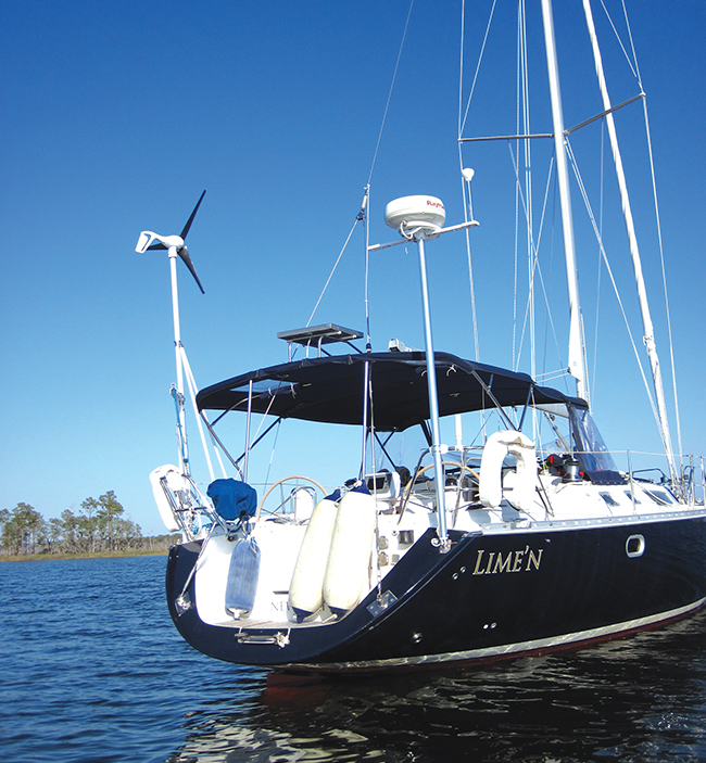
Navigation Systems for Cruisers
After a lightning strike, we had to replace all of our electronics-it was an eye opening task (published January/February 2018)
A couple of years ago we were struck by lightning just as we were leaving West End, the Bahamas on our way north to our home port in Newport, RI. The storm was a monster thunder and lightning show in the Gulf Stream that went on for six hours. We didn’t actually feel the strike and we didn’t lose our electronics all at once as you might expect from a direct hit.
But, over the next few days as we sailed north towards Hatteras, gremlins started to appear in the electronics. The autopilot developed a mind of its own and would suddenly shift 20 degrees to port. The chartplotter (MFD) would lose the GPS position and would need to be rebooted to reacquire it. Even the radar would shut itself off without warning and need to be rebooted to start it up again. Something was definitely wrong.
We had a great trip north despite the gremlins and were able to work around the issues with a little extra diligence. When we got home, we got the system checked by our pals at Cay Electronics and they couldn’t put their finger on the exact problem but they could see that things were amiss. We contacted our insurance company who sent a surveyor to check out the system. The conclusion was that the lightning strike had fatally damaged the entire electronics package so our system was condemned and the insurance company agreed to replace with all new gear. That meant we had to start from scratch and design for ourselves, with the help of the experts at Cay, an entirely new and modern navigation system for the boat.
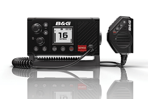
The latest developments in MFDs have made these all purpose navigation tools easy to use and very sophisticated. On some models on the market, such as the B&G MFDs, you will find that a lot of functions specific to sailing have been included in the software so you can generate your best sailing angles, the right times to tack and how to interface your sailing data with current and tide information.
We use Navionics digital charts on the chartplotters so these had to be reloaded and then updated via a laptop and the online updates. Navionics has a crowd-sourcing online function that allows users to submit chart updates for review and possible posting.
Because of the ability to share data from instruments and sensors across the network we felt it was important to go with a single manufacturer so we would be confident that each unit would talk seamlessly with the whole network. In our case, we had Raymarine on the boat when lightning struck so the insurance company replaced it with the same brand and similar but newer models. The MFDs we installed were the 12-inch eSeries models that can display and control all instrument functions with the exception of the autopilot. The processors in these units are so fast these days that screens refresh almost instantaneously. We have used the B&G, Simrad and Furuno MFDs which have similar refresh rates and the full range of functions.
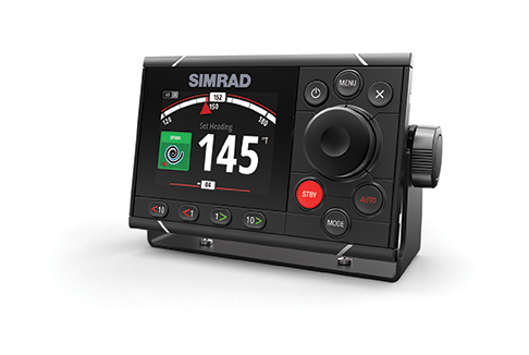
From our point of view, the MFDs and GPS are the basic navigation system but to get the data you need to allow the software to do its job – in our case Lighthouse 1 – we needed to include a depth sounder, speedo-log and wind instruments and individual multifunction displays where the data can be viewed right at each of the twin helms. We chose the i50 displays with one each for speed, depth and other functions and one each for wind speed and true and apparent wind direction. With boat speed, course, chart, wind speed and direction and GPS data flowing to the MFD, the software can calculate true wind speed, apparent wind speed, true and apparent wind angles, speed through the water, velocity made good, current or tide direction and speed and laylines for favored tacks.
With this navigation system you could sail safely anywhere in the world, although you might find that the digital charts for some remote areas have not been updated with GPS based geo surveys. Once when anchored in the middle of the large harbor at Nuku Hiva, The Marquesas, French Polynesia, the GPS showed us positioned a mile inland on top of a 3,000 foot mountain.
THE FULL SYSTEM
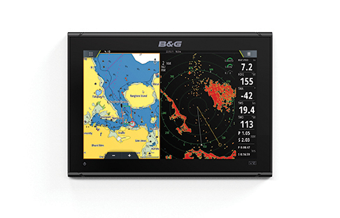
The autopilot replacement involved a new cockpit mounted control head (p70), a new computer and sensor and a new drive unit. The latest systems from Raymarine and their competitors are so sophisticated that they appear to be very simple. With multi-directional sensors and digital compass input, the new autopilots can calculate sea states, yaw rates, pitch rates and adjust the speed and force of the helm corrections accordingly. We often use the wind instrument interface to set the pilot to steer to the apparent wind – much as a mechanical windvane does – and the new autopilot, after installation and tuning, drove the boat like a veteran helmsman.
The new digital radars, like the 48-mile unit we installed, have a lot of cool features. They turn on and off more quickly than our old analog radar, have a much sharper image, easy to use gain and filter functions and are excellent at focusing on objects close to the boat, an area that often was a dead zone for earlier radars. Plus the scanner is smaller and lighter (only 21 pounds) than the radar it replaced.
There are a few ways to use radar on the MFD. You can show the digital chart in one screen with the radar image in a second screen next to it; this gives you the real world that the radar is actually seeing with the digital world in the chart next to it with both screens being clear and easy to read.
Or, you can overlay the radar images right on top of the digital chart so the real world and the digital world can be viewed together. If the digital chart is not completely accurate, the difference between the overlay and the chart can be alarming.
The last item we installed in the new navigation system was new to us and not covered by the insurance. But, it is one of the most valuable new electronic tools to be developed in recently years and that is an automatic identification system transceiver (AIS). The AIS operates on the VHF bandwidths so the signal it receives from other vessels and the signal that you broadcast from your boat are line-of-sight. Depending on the height of your antenna, the range can be from 10 to 40 miles.
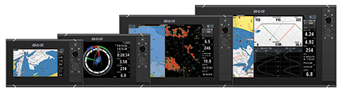
AIS gives you the data you need; scroll over the image on the MFD of a ship that is heading toward you and you will get the ship’s name, home port, speed, course, destination and the time to possible collision. With this information, you can call the ship by name on the VHF radio with the high likelihood of getting a reply…because the ship sees you on their MFD and knows who you are and the likelihood of a collision.
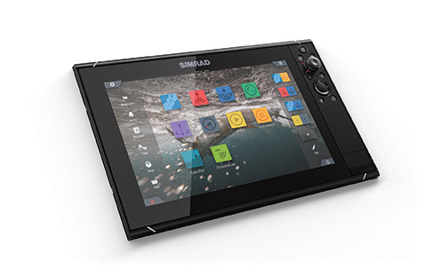
THE WISH LIST
Our boat was amazingly well tricked out with the latest marine electronics when all was said and done. We had everything we needed and more. But that doesn’t mean we can’t pine a bit for the latest and greatest new thing. What’s on the wish list?
First, a satphone with a built-in dome antenna so we can communicate easily and thus work from the boat. But these are expensive and still not fast enough to really work online. So, the simpler solution would be the new IridiumGO that provides a good connection to the Iridium satellites and enables quick and efficient email through which you can access all sorts of information, data, weather forecasts and so forth.
Second, is a single sideband HF radio (SSB). While the technology is old fashioned it still works and provides a level of communications redundancy that adds to the overall safety picture aboard our boat. To this we would add a Pactor modem and one of the radio email programs such as Sailmail through which we can send and receive email and get good weather forecasts.
Lastly, we’d add a FLIR thermal imaging camera mounted up the mast, probably on a spreader, that can pan around in a circle and up and down remotely. These cameras show their thermal images on the MFD screen and give amazing clear images; they allow you to actually see in the dark and can be incredibly useful in a man overboard emergency or just when trying to find and pick up a mooring in total darkness.
I would never want to be struck by lightning again, and we know a few skippers who have been struck more than once, but going through the process of refitting our boat with an all new electronic navigation system was an eye-opener.
Author: George Day
Leave a reply cancel reply.
- BOAT OF THE YEAR
- Newsletters
- Sailboat Reviews
- Boating Safety
- Sailing Totem
- Charter Resources
- Destinations
- Galley Recipes
- Living Aboard
- Sails and Rigging
- Maintenance
- Best Marine Electronics & Technology
Modern Sailboat Autopilots
- By Dave Schmidt
- Updated: May 8, 2019

Hand steering is one of sailing’s greatest joys, but the truth is that most sailors struggle to hold an accurate course for more than 30 minutes. This is why racing crews regularly rotate drivers, and why most cruising sailors carry an autopilot that can handle helm duties when the weather turns bleak, attention deficits lurk or other onboard responsibilities take priority over chasing the compass card.
While autopilots have been steering recreational sailboats since Derek Fawcett introduced his original Autohelm in 1974, contemporary systems use solid-state components, cutting-edge processors and powerful algorithms to deliver significantly better performance and advanced features to aid in getting from Point A to B. Here’s a look at what’s on the market and the important things to consider when shopping for a new electronic hand on the helm.
At their core, autopilots consist of four basic components: a black-box central processing unit (CPU), which is the system’s brains and power supply; a hydraulic or electric drive unit that delivers the brawn that physically turns the boat’s rudder; a control head, which the helmsman uses to set a course with the touch of a button; and a heading sensor, commonly a fluxgate compass. Additional bells and whistles, such as a rudder-indicator sensor, a wind-and-speed sensor, and GPS and chart plotter can also be tied into the pilot system via an NMEA 0183 or NMEA 2000 network, allowing the autopilot to access the boat’s navigation system for increased functionality (more on that later).
In its simplest application, once the autopilot’s installed, a skipper manually steers the boat onto a desired course and engages the autopilot using the control head, which is typically mounted near the helm station. Course adjustments are typically made in increments of 1 and 10 degrees, either via hard-key buttons on the control head, a handheld remote control or an app.
When engaged, the autopilot relies on external sensors and internal algorithms to apply the least amount of rudder movement to maintain course. No matter who’s driving, excessive rudder movement directly equates to drag. While autopilots don’t fatigue in big waves the way a sailor might, they do consume more juice when they’re working hard, so autopilot manufacturers develop software controls to properly hold course without sapping boat speed or draining the batteries.
One of the most critical decisions when choosing an autopilot is ensuring that the drive unit is properly sized for the boat. “It’s all based on the boat’s displacement,” says Jim McGowan, Raymarine’s Americas’ marketing manager. When selecting a drive, he advises, “You want to use the boat’s dry weight and then add 20 percent to account for fuel, people and their gear.”

Autopilot drives are typically designed to work up to a certain weight, and it’s important to both performance and safety that this is properly matched as this in turn will dictate the system’s power requirements. Most sailboat-friendly autopilots draw between 2 and 7.5 amps, depending on the size of the CPU required by the system. While the CPUs in a given model range will typically employ identical algorithms, the bigger CPUs deliver more power to their drives.
When buying an autopilot system, be sure your vessel falls well within the designed working range. “When you fall on the line, you always want to go up,” advises McGowan. “It requires a lot of torque to drive the rudder arm in big seas, and if the pilot is up against its limit, there’s a lot more stress on the equipment and more heat buildup in the control unit.”
Matt Fries, B&G’s business acquisition manager, advises that customers should also take into account the design and sailing characteristics of their boat when selecting a drive. “A 40-footer with a full keel and an aft-hung barn-door rudder might require a more powerful drive than a 50-footer of the same displacement that has a more balanced rig/keel configuration and a more modern rudder design,” he says. “It’s more important that the drive suits the boat than who makes it. If [a boat’s] existing drive works and is proven, we’re fine using it.” This same drive-system agnosticism exists amongst most manufacturers and potentially opens the door to cost-effective modular autopilot upgrades, as most modern autopilots can be matched up to power and control different drive types.

As with all electromechanical systems, the course that the autopilot steers is only as accurate as the input of its sensors — in this case, the most critical data is the vessel’s compass course. While fluxgate compasses provide accurate azimuth information, their reporting rates of 1-10 hertz are sluggish to report course changes compared to today’s nine-axis compasses, which feature updated rates in the ballpark of 10-30 hertz, or that number of times per second. Moreover, the new breed of compasses are accurate to roughly plus or minus 2 degrees magnetic, and also deliver pitch, roll and yaw information, and in some systems, even heel angle. All this data means the autopilot’s CPU and algorithms can more efficiently stay on course. When networked with other onboard devices, the data can also account for vessel motion and the affect it has on wind angle and speed data. As a result, nine-axis compasses have largely usurped fluxgate compasses.
“The EV1 is the system’s decision maker,” says McGowan, describing the role of the solid-state attitude heading reference system (AHRS) that’s central to Raymarine’s Evolution autopilot system. “All smarts are in there, and it sends its command signals to the control head and the drive.” The system is upgradeable, allowing Raymarine to push new features out to existing Evolution autopilots.
While nine-axis compasses have become the industry standard for autopilot heading sensors, even more precise options exist. “Furuno pilots interface really nicely with our SC33 satellite compass,” says Eric Kunz, Furuno’s senior product manager. And, he notes, the cost for these sophisticated compasses has been dropping. “It delivers roll, pitch and heave information, and it’s accurate to .5 degrees, which allows the system to steer a straighter course.”
As previously mentioned, modern autopilots are typically NMEA 0183 or NMEA 2000 compatible, allowing their information to be displayed and sometimes controlled via the vessel’s chart plotter. “One thing that’s changed dramatically is that you used to need a dedicated control head, but now plotters can control this,” says McGowan. In other words, Raymarine chart plotters can control the company’s Evolution autopilots. While this capability exists across all brands, not everyone is sold on chart-plotter control alone.
“I wouldn’t go to sea with just a chart plotter controlling the autopilot,” says Kunz, citing safety risks. “With our NAVpilot-711C, you need a connection between the processor and the control head and the heading sensor.” Up to six control heads can be added to the system.

Irrespective of what interface a boat owner employs, today’s autopilot systems offer new capabilities and sailing-specific features. Perhaps most publicized is their ability to auto-calibrate and adapt to a vessels particular motion underway.
“Before our Evolution autopilots, it took a lot of work to get a [Raymarine] autopilot set up and calibrated,” says McGowan. “You had to spin circles so that the autopilot could figure out the boat’s magnetic deviation.” By contrast, Evolution pilots automatically “learn” the boat’s turning characteristics over time. They work right out of the box, and their AHRS sensors are so sensitive that they can calculate what’s happening on the boat in real time.
While this is great for anyone who hates owner’s manuals, not all experts are ready to trust in technology alone.
“All autopilots should be properly commissioned and sea-trialed to ensure proper steering performance before being put into service,” says Fries. While B&G’s pilots support auto-calibrating and self-learning capabilities, there’s useful information that’s best gleaned the old-fashioned way. “After swinging the compass, the system gives you a field percent score, which shows the ratio of the boat’s local magnetic field to the earth’s magnetic field. I like to see less than 15 percent.” (See “Smartphone Detection,” below)

Once set up and calibration is complete, users can dial in the amount of acceptable cross-track error when underway. Furuno, for example, offers two different driving modes: economy and precision. “With precision mode, we’re trying to keep the boat right on the cross-track line,” says Kunz. The system essentially sets a waypoint 100 miles out and maintains a course that’s within a 6- to 10-foot accuracy zone. In economy mode, the system lets the vessel’s course drift more, so there’s less rudder movement and drag. Kunz says this is especially beneficial to bluewater sailors.
Another interesting feature involves using the vessel’s cartography and chart plotter capabilities to automatically generate a route, which is sent to the autopilot as a series of waypoints. “If you’re using a Garmin chart plotter, running Garmin’s g3 cartography and using a Garmin autopilot, the system will follow a route that was generated by auto-routing,” says Dave Dunn, Garmin’s director of sales and marketing for marine. Furuno also offers similar capabilities thanks to its ownership stake in TimeZero (née Nobeltec and MaxSea). “TimeZero can take in the boat’s polars and take into account wind [forecasts] and the best time to go,” says Kunz. Skippers using computers that run the necessary Windows-compatible software can access this same functionality using a USB gateway that connects to the autopilot’s processor.
While NMEA 0183 and NMEA 2000 compatibility between the autopilot CPU and a chart plotter or computer has in some cases eliminated the need for a dedicated control head, it has also opened the door for app-based remote control. Contemporary chart plotters are all Wi-Fi enabled and most manufacturers, including Garmin and Furuno, build smart-device apps that deliver wireless plotter control, and therefore autopilot control. For the record, B&G and Raymarine do not allow this functionality for safety reasons.
In addition, Garmin allows users to control their autopilots via a quatix 5 watch and the company’s new Reactor Autopilot Remote controller, which features gesture control (see “Mind Control,” left). “You just point it to a heading, and the boat will sail the course,” says Dunn. As of now, Garmin is the only manufacturer to offer a gesture-sensitive control for a sailboat-compatible system, however Furuno makes a similar remote control for its powerboat-specific NAVpilot 300.
Recent years have also seen the advent of newer sailing-specific software features such as B&G’s ability to steer to specific wind angles. “If you engage the pilot’s wind mode, it will steer apparent wind angles, and downwind it will steer true wind angles,” says Fries. “The idea is that it’s easy to sail to the telltales upwind, but when you’re sailing downwind in seas, true wind angle is more stable and can avoid a crash gybe.”
McGowan says Raymarine has updated the Evolution’s ability to steer a course using a windvane as well, and it has also improved the system’s ability to perform automatic tacks when sailing to weather without overstanding its new course.
Finally, modern autopilots usually offer some sort of man-overboard mode, be it prescripted driving patterns or the ability to hold the bow in irons.
NKE takes this a step further with its system-agnostic Crew Transmitter, which establishes an electronic link with your nav system that’s broken if a user-worn pendant travels more than a certain distance away. Should this happen, the nav system drops a pin and triggers onboard MOB alarms. Using NKE’s Gyropilot remote control system, if an NKE autopilot is engaged at the time of the crew-overboard incident, it will either turn the boat into the wind or, if there’s no networked wind sensor, put the helm hard over.
Given the increased functionality, features and performance of modern autopilots, there’s little reason to suffer long stints at the wheel unless, of course, you feel like steering just for the fun of it.
David Schmidt is CW_’s electronics editor_.
Autopilot Manufacturers
- B&G : 603-324-2042; from $2,300.
- Furuno : 360-834-9300, from $3,400.
- Garmin : 800-800-1020, from $2,000.
- NKE Marine Electronics : from $5,400.
- Raymarine : 603-324-7900, from $2,000.
Smartphone Detection
Magnetic interference is a time-honored autopilot headache and can be triggered when equipment is loaded aboard or new systems are added. While properly installed, self-learning autopilots will eventually detect — and correct for — this interference, a smarter and more immediate tip, says B&G’s Matt Fries, involves using an app. “Everyone has a smartphone, and there are [deviation-sensing] apps that measure the boat’s magnetic field,” says Fries. “An owner might not realize that there’s an [outboard] motor behind a bulkhead.”
If there’s a magnetic-interference issue at play, this trick, coupled with the field-angle percentage that’s generated when swinging the boat and autopilot compass, should reveal the culprit.
Mind Control
An 8- to 10-knot southerly blew across Seattle’s Portage Bay as John Tenneson, owner of the nicely appointed J/145 Jedi , handed me Garmin’s new gesture-enabled Reactor Autopilot Remote controller, which was wirelessly tethered to Jedi’s Garmin autopilot. I aimed the controller 10 or 15 degrees off the port bow, pressed a button and Jedi immediately responded. Next, I made a slower turn to starboard, followed by a few dozen more maneuvers, executed simply by gesturing and pressing.

The remote also handles industry standard 1- and 10-degree course correcting commands and features three user-programmable hot keys, a dedicated MOB button and the ability to initiate auto tacks, based on apparent wind angles. The auto tack feature is especially helpful for shorthanded upwind work.
- More: autopilots , Gear

C-Map Updates North America Charts

Setting Course for a More Sustainable Future

Raymarine Expands LightHouse Charts

Push-Button Convenience

New to the Fleet: Italia Yachts 12.98

St. Vincent Court Orders Deportation For Hijacking Suspects

The Moorings: The Journey is the Destination

An Oasis in the Middle of the Atlantic
- Digital Edition
- Customer Service
- Privacy Policy
- Terms of Use
- Email Newsletters
- Cruising World
- Florida Travel + Life
- Sailing World
- Salt Water Sportsman
- Sport Fishing
- Wakeboarding
Many products featured on this site were editorially chosen. Cruising World may receive financial compensation for products purchased through this site.
Copyright © 2024 Cruising World. A Bonnier LLC Company . All rights reserved. Reproduction in whole or in part without permission is prohibited.
- Pontoon Boats
- Personal Watercraft
- nauticalknowhow
- Nautical Knots
- Tools and Calculators
Ranking the Best Marine Radar Systems of 2024

Raymarine RD418HD HD Color Radome

Raymarine Quantum 2

Furuno Defender

Marine radar used to be a pipe dream for most boaters. A cool sounding gadget, but totally impractical. How could any regular boater use it? Why would they ever want to? It was for commercial freighters and ocean liners. But you can’t stop progress. These days marine radar has come home. There are plenty of small, portable, affordable units.
Radar is one of the greatest inventions ever in terms of boat safety. Navigating in rough seas and fog was far more treacherous before it came along. Now, with radar, a clear path can always be found. Unseen obstacles and oncoming vessels need not be a danger or a surprise.
If you’re a serious boater, you want to have the best marine radar you can get. But what makes for the best marine radar? Let’s take a look at some of the best marine radars on the market. Then we’ll go over what features you need, and why you need them.
With a range of 48 nautical miles, the Raymarine Color Radome operates on 4 kW of power. This kind of radome antenna operates on plug and play technology. It’s easily compatible with a lot of other hardware. Compared to the typical 24 nautical miles, this has a great range.
The Raymarine color radome scanner features an adaptive digital receiver. That means you’re going to have a clear picture no matter what. It easily adjusts to changing weather and sea conditions. It also takes environmental changes into effect quickly and easily as well.
The multi-level target display operates in 256 colors. It even features a bird mode. That means it can detect a flock of birds at a distance. Why is that important? It can show you where a school of fish is that the birds are feeding off of. That can save a lot of time hunting down fish . Just let the gulls and pelicans do it for you.
Dual range mode lets you scan near and far simultaneously. At 21 pounds, it’s not an overly huge unit, either. That means this is ideal for a smaller boat. It features everything you want in a compact shell. It won’t stand out and look awkward on your boat, either.
For the features and the price, Raymarine has hit it out of the park with this marine radar.
$2,179.99 Amazon →
The Raymarine Quantum marine radar is definitely at the head of the class. It will set you back more than the RD418HD but it’s worth it. It features CHIRP pulse compression and Doppler collision avoidance. Raymarine’s advanced tech can instantly highlight moving radar contacts. Once it does, it can color code them for easy tracking at a glance. It will tell you if they’re coming towards you or moving away.
In high-traffic areas, Raymarine’s Quantum takes a lot of guesswork out of navigating. A quick glance can let you know what’s a potential danger. At the same time, it shows you what’s moving away.
Raymarine’s Quantum also features MARPA tracking. This is used by the U.S Coast Guard. It keeps an eye on dangerous targets. That way you can avoid collisions.
Additional features include TrueTrails target history. This can show you the path other vessels have taken. The CHIRP pulse compression can show you anything even in the thickest fog. And it can identify it as close as 18 feet away.
It has a 24 nautical mile range for traffic detection and immediate awareness. That means it’s on and ready instantly.
Installation is easy and the unit is lightweight. Raymarine boasts it’s actually 50% lighter than similar units. All in all, if you want one of the best marine radars and price is no obstacle, give this a try.
- Buy on Amazon →
- Buy on Walmart →
With some marine radars costing over $5000, the Furuno Defender is a welcome change. At a fraction of the price, it still offers reliable functionality. The price is definitely not the only bright spot here. For people who don’t want to get too complicated with technology, this is a breath of fresh air. The Furuno Defender can be hooked up to a smartphone.
The 4kW power output gives you a 24 nautical mile range. That makes it ideal for smaller boats and casual sailors.
The Defender operates something called DRS4W radar. It is compatible with all iOS devices. All you need to do is download their app in the app store. It’s free and very user friendly.
Once using the app, you gain a lot of functionality. You can slip between day mode and night mode. Target distance is also available. You are also able to set up a guard zone around your boat. This means that if the radar detects anything within that zone, your phone will alert you.
The unit is sturdy and can handle winds up to 70 knots. You’re also covered in high heat or freezing cold. It’s also sturdy and waterproof to meet all your needs.
Amazon →
Garmin GMR Fantom Marine Radar

The Garmin GMR 18HD+ offers great performance at a reasonable price. The power output here is 4kW, and it provides a range of 36 nautical miles. The images are clear and precise. That includes close up as well, with range detection as close as 20 meters from your vessel.
The Garmin GMR has dynamic auto gain. That means even in poor weather you can expect a good image. It can be easily paired with a heading sensor for increased functionality. Hook it up to a multifunction display and you are ready for MARPA tracking. The unit is compact in size so it will fit nicely on any boat. Installation is also fairly easy.
The Dynamic Sea Filter adapts to changing sea conditions. That ensures you don’t lose signal or clarity regardless of what’s going on. Radar images are overlaid on the chart plotter. That means you have improved navigation capabilities.
Simrad Halo 20+ Marine Radar

The Simrad Halo 20+ has a range of 36 nautical miles. It uses pulse compression technology and features beam sharpening. The dual range mode lets you see at a distance and also close up. With 60 RPM operation you can see close up almost instantly to 1.5 nautical miles.
The Simrad features VelocityTrack Doppler technology for collision avoidance. This will help you keep track of any hazards on the open water. You can steer clear of other vessels and objects well ahead of time. It operates in several modes. These include harbor, offshore, weather, and bird modes.
It also features MARPA target tracking. This lets you follow 10 targets simultaneously. If you’re using dual range, it doubles to 20.
Unlike some systems, the Simrad is ready instantly. There is no warm up period during which it has to build up. If you plan to stay close to shore, the Simrad Halo may be the best marine radar for you. The speed and accuracy help you identify close range targets. This can be done faster than almost any other marine radar out there.
- $2299.99 Bass Pro →
Furuno 1815 Color LCD Marine Radar

The Furuno 1815 4kW marine radar features an 8.4 color LCD display. This means you don’t need to worry about having to try to integrate boat radar into your GPS or chart plotter. It’s an ideal unit for fishing boats. Or just pleasure boating. The radome antenna is small and won’t take up a lot of space. The installation is simple and easy to understand. Also, the controls are highly intuitive. Mastering the functioning will not take much time at all.
Details are displayed clearly and in full color on the display. Fast Target Tracking lets you follow up to 10 targets at one time. True Trail mode also displays the path objects are on. It then compiles that data over time so you can see where an object is and how it got there. The range extends up to 36 nautical miles.
Walmart →
Things to Consider
Not every marine radar is built the same. There are several factors that can affect which one is best for your boat.
Radar System Range
Marine radars come in different ranges. Think of it like binoculars. Depending on the lens and prism type, some can see a great distance. Others have a much more limited range. So then the question becomes what range do you need and why?
If you’re a casual boater, you may not need any great range. If you tend to stay near shore, a limited range will work perfectly for you. It can still show hidden hazards and vessels in fog.
If you’re interested in more serious boating, a greater range is needed. If you plan to do boating a good distance from shore, this will be helpful. Likewise, if you’re an explorer and want to head to unfamiliar waters. A long range boat radar will eliminate any surprises.
An average range is 24 nautical miles or 26 nautical miles. Even up to 48 nautical miles. 36 nautical miles is rather rare, but it’s a sweet spot in the middle. The best marine radars need to have range plus clarity.
As you can imagine, a more powerful marine radar is typically a better marine radar. A more powerful engine goes faster. A more powerful shower cleans better. It’s just how things work. Power is different from range, although range is definitely affected by power.
A low-powered marine radar will have trouble getting through severe weather and fog. Heavy rain will slow it down as well. These obstructions absorb radar, making it less functional. More power will help it cut through them.
Power for a marine radar is measured in kilowatts (kW). The typical range for a marine radar starts at 4 kW and goes up to about 25 kW. A 4 kW radar has a maximum range of about 48 nautical miles. At 25 kW you’ll get a maximum range up to 96 nautical miles.
There are lowered power marine radars you can get as well. Some down as low as 2 kW. These only have a maximum range of about 24 nautical miles.
The ability of your marine radar to function can be tweaked by more than just power. For instance, a taller antenna can help improve range and power as well.
Types of Marine Radars
Not every boater is aware that marine radars come in different types. They perform the same basic function but operate slightly differently.
Pulse Radar: These are the older style of radar system. They create microwave pulses with high powered magnetrons. It’s rather similar to how a microwave oven works. The pulse are released in short bursts of voltage. Though older, it’s still reliable radar technology.
Solid State Radar: Solid state is the newer style of radar system. It’s also called broadband marine radar. Solid state uses something called Frequency Modulated Continuous Wave technology. This is sometimes abbreviated to FMCW.
Solid state marine radars use less radiation than pulse radar. That’s another thing people don’t often consider. Radar does release energy that could potentially be dangerous. Keep in mind that it’s unlikely you’ll be exposed to a dangerous dose, however. It would take a long time.
Solid state radars are easier to install than pulse. They don’t need to warm up the way a pulse system does, either. They have improved range even using the same power. And they also have a better target resolution.
Most marine radars have a beam width of 5.2°. A narrower beam width is going to provide you with a more detailed image. This is especially true of an object that is far away. It’s like focusing on something with a flashlight beam. But there is a downside. Narrow beam width tends to miss things as well. The narrower your beam, the more likely it is to skip important objects. So you need to have a happy medium. Too wide and resolution suffers as well.
Compatibility
Marine radar systems work in conjunction with other technology. On its own, radar won’t do much, right? You need to see the data it collects on a screen. That means tying it into your GPS or chart plotter.
Some radars come with their own GPS and chart plotter hardware. But most boats will already have a GPS or chart plotter on board. It’s more efficient to tie them together. But you need to make sure your radar actually works with what you have. If not, you’ll need to have some extra technology on board.
Just as with anything else on your boat, you need to settle on a budget for a radar. Even a “cheap” radar is an investment. Some kinds of radar systems can get well over $5000. For that kind of money, you want to make sure you’re getting quality technology.
Cheap radar systems do exist. But never forget that you get what you pay for. If you find a bargain radar, always research it. Check reviews across several sites. Especially if it’s a brand you have never heard of. If you can’t get some reliable history and reviews, you may want to skip it.
Boating Habits
The way that you boat can dictate how you use marine radar system. As we covered, weather can affect how radar systems work. But if you do boating at night, for instance, that has an effect as well. Early morning boating can benefit from high powered radar as well. If you have a fishing boat, you can get a marine radar system that is also a sonar. That way you have the benefit of a fish finder.
Casual boaters will probably just need a simple marine radar system, if they need one at all. But if you’re a real gadget head, then maybe a more intense system is needed.
Choosing the place to mount your radar is as important as the type of radar. If you mount it wrong, it will limit function. Improper mounting makes blind spots. If the radar is obstructed by other parts of your boat, it can render it useless. Your radar should come with a mounting kit. This will always be the best way to mount it. If it doesn’t, you need to do a little homework. Find out the best way to mount your specific model.
At the very least, radar needs to be mounted above the passengers on the boat. This keeps you out of range of the electromagnetism that is being used. You want to look for the highest possible point on the boat. That way the radar can operate at a full 360 degrees.
Waterproofing
Everything on a boat needs to have a degree of waterproofing. That just makes sense. But electronics can be touchy. You wouldn’t want to dunk your GPS or radio, right? The radar is the same way. It needs to be waterproof, however. It’s going to be exposed to sun and surf.
Radar units have specific waterproof ratings. You want something rated IPX6 at least. The IPX scale rates devices based on their water resistance. It runs from IPX0 to IPX9K.
An IPX0 has no water protection at all. At IPX6 it can resist high-pressure, heavy sprays of water. This is ideal for a boat radar. It should be enough to keep it safe in rough seas. It is rare you would find anything above IPX6.
IPX7 means it can be submerged for 1 meter for up to 30 minutes. It is unlikely you would find a radar system that has this rating or above.
Not every radar system is the same size. If you have a small boat, you need a small radar. Not for technology reasons, but for practical ones. Large radar units will be harder to mount if you don’t have the space.
Check the dimensions before you buy. Make sure you have the open space to mount it safely. Likewise, a heavy radar unit could pose an installation and safety issue. Some of these units weigh around 20 lbs. If these are not securely mounted, they could be a danger if a storm tears them free. Mounted in a high space, you don’t need a 20 lb radar hitting you in high winds.
My grandfather first took me fishing when I was too young to actually hold up a rod on my own. As an avid camper, hiker, and nature enthusiast I'm always looking for a new adventure.
Categories : Boats

Shane William Savell on May 25, 2021
Hi, looking for small boat 30foot or do, radars with PI lines. Parallel index lines. Any comments. Cheers. Sav

David L on October 25, 2022
Something for your readers to consider. Will a radar pick up whales in the water. The answer is a resounding no! How then do some radars detect whales. Answer – the same way they all do. They won’t reflect off a whale, they will reflect off the hole in the water a whale makes. This explains why whales come and go on radar. When near the surface they make a “visible” hole in the water. When they dive – they disappear!
The radar horizon for an antenna is about 7nm at sea level and increases to about 12nm for a 100 foot antenna. The power out on a radar is not the critical factor when selecting a product. Your range is obviously extended when detecting targets which are higher than sea level. EG the mast of a merchant ship.
The statement above “The ability of your marine radar to function can be tweaked by more than just power. For instance, a taller antenna can help improve range and power as well.” is misleading, when you say a taller antenna I presume you mean a higher mounted antenna? (A taller antenna in the shape of the reflector would provide no benefit in the marine environment.)Height of the antenna may improve range as described above. It will not provide more power, this is purely a function of transmitter power. For example to double the range of a radar you have to increase the power out by 8 times.
Leave a Reply Cancel reply
Your email address will not be published. Required fields are marked *
Save my name, email, and website in this browser for the next time I comment.
More in Boats
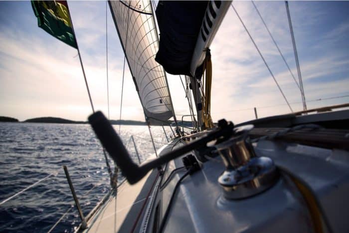
What Is A Gunwale?

131 of the Best Hawaiian Boat Names
167 Patriotic Boat Names
The 138 Best Boat Names for Dog Lovers

The People’s Poncho Review and Ratings

Oru Lake Kayak Review
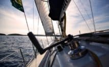
About Boatsafe
Established in 1998, BoatSafe is your independent guide into the world of boating, fishing, and watersports. We provide expert insights and detailed guides to help you find products tailored to your needs and budget.
Contact Boatsafe
- Address: 4021 West Walnut Street. Rogers, AR 72756
- Phone: (479)339-4795
- Email: [email protected]
Site Navigation
- How We Test
- Corrections Policy
- Privacy Policy
- Terms & Conditions
- Editorial Policy
- Affiliate Disclosure
Our Reviews

All content is © Copyright 2024. All rights reserved.
IMAGES
VIDEO
COMMENTS
Whether you are out on a fishing spree or riding a schooner, boat, or yacht exploring, a marine GPS keeps you on your intended route. So, the elite marine GPSes in 2024 should always make your priority checklist when heading out into the water. Whether you are an amateur sailor or an experienced professional on the boat, a GPS utilizes ...
Simrad GO7 XSE Chartplotter. Perfect for various types of sailboats including day boats and sports boats, this is your perfect solution if you're looking for an easy-to-use chartplotter. Its shiny display touchscreen is intuitive and offers one of the best screen features. For example, you can easily zoom in by just pinching the screen and it will show you your routes, waypoints, underwater ...
The Vulcan 7 continues this tradition, wrapping an impressive array of sailing-specific features into a compact, durable, and affordable chartplotter. The screen is bright and versatile, displaying all of your sailing and wind information with layline and tacking options overlaid on up-to-date navigational charts.
The GPSMap8400 can be supplied with Garmin's exclusive optional BlueChart g3 and BlueChart g3 Vision charts with integrated Navionics data. Reasons to buy: Connectivity to many other Garmin ...
Marine Charts for Sailing. Raymarine navigation displays give you the power to explore, plan and navigate the open water, with confidence. High definition displays and quad-core performance brings electronic charts from leading mapmakers to life. Enjoy fully featured vector charts, high-quality raster charts, plus advanced features like 3D maps ...
iSailor. iSailor is another app that works well as an extension to your boat's onboard systems. It will connect to the NMEA system and internet AIS, although each feature you unlock costs money ...
At the more premium end of the budget spectrum, we have the Garmin Echomap Plus 94sv. It's an advanced GPS system with a useful 9-inch display and advanced fish finding technology. It's pre-loaded with Bluechart G3 coastal charts, and Great Lake charts too, so it's ideal for both saltwater and freshwater explorers.
Garmin Striker Plus Marine GPS 5CV with Transducer. The Garmin Striker Plus 5CV is one of the most advanced GPS units available to fishermen. It has a mix of features that make it perfect for boat trips and fishing excursions, providing you with detailed information about what is happening beneath the surface.
6. Garmin GPSMAP 78sc Handheld GPS. Another great Chartplotter from Garmin sets its place in our reviews. This handheld sailing navigator comes with a color TFT display and a 2.6-inch screen size which makes it a perfect fit for your boating, kayaking and any other water sport activities.
Above: A Garmin Navigation System with two flush-mounted, in-dash, 24″ Garmin displays onboard a 2020 Yellowfin 42 Offshore for sale on Boat Trader. Photo by USA Coastal Marine. ... Best Boat GPS Systems for 2021. With so many GPS systems available for boats, choosing the one that meets your needs can be a challenge. There are tons of ...
Best boat GPS systems available right now. Garmin GPSMAP 86i. Specifications: Screen size - 3 inches, battery life - 200 hours, adjustable GPS filter. Reasons to buy: State-of-the-art, IPX7 waterproof rating, doubles up as a satellite phone. ... While the unit's navigation capabilities are limited, what the M94DE can do is provide a much ...
The Garmin Ghc 20 Marine Autopilot Helm Control is your best sailboat autopilot for these types of adventure. This amazing autopilot is designed with a 4-inch display that can improve your nighttime readability. This display is glass-bonded and comes with an anti-glare lens that is essential in preventing fog and glare in sunny conditions.
GPSMAP® 86sci. This handheld marine GPS provides everything you need for a safe day out on the water. With its built-in inReach® Satellite Communicator 1, it also acts as an emergency beacon. Install it at your helm or take it with you to a different boat — portable marine navigation, made easy.
The Zeus S comes with new sailing modes, preset dashboards and data views for a variety of sailing situations, along with many enhanced features for a simpler sailing experience. The home of B&G Sailing. The leading manufacturer of Sailing Electronics including Chartplotters, Instruments & Autopilots around the world.
The Humminbird HELIX 12 is a 12.1-inch chartplotter with built-in Ethernet networking, AutoChart Live technology, and Dual Spectrum CHIRP Sonar. This unit also has an internal GPS with Humminbird Basemap preloaded, NMEA 2000® connectivity, and side imaging/ down imaging capabilities.
GPS allows you to find yourself anywhere in the world with great precision. GPS is a satellite-based navigation system that provides accurate position fixes 24-hours a day on land, sea and air in any weather with no subscription or fee. This nominal constellation features 32 satellites in medium Earth orbit (MEO) 12,550 miles above the earth.
iSail GPS. This is the cheapest app of those reviewed, and there aren't any signups, pop-up ads, or in-app purchases to spoil the experience. This isn't the most comprehensive navigation app, but a solid, easy-to-use, no-frills navigation tool. Easily measure distance between two points of interest, and import and export waypoints, routes ...
How to plot a course on a chart: Draw a line from point A to B - using parallel rules, from starting mark to next mark. Check the line for safety - if not, move end mark until you get a safe leg. Measure and mark the heading - transfer the leg to compass. Measure and mark the distance - measure the legs.
The largest boat in our fleet, the Oyster 745, also features one of the largest nav stations among the monohulls. This aft-facing desk area, on the port side of the companionway, will serve its owners and crew as an ample office space. This station has room for two large multifunction displays, plus smaller instruments.
2. iNavX. Easy to confuse with Navionics (especially when downloading the app), iNavX is a whole different animal. There's a $5 charge to download the app, and then you can download NOAA raster charts for free and vector charts (powered by Navionics and C-MAP) for a fee. Beyond navigation, details on marinas, fuel docks and other facilities ...
With boat speed, course, chart, wind speed and direction and GPS data flowing to the MFD, the software can calculate true wind speed, apparent wind speed, true and apparent wind angles, speed through the water, velocity made good, current or tide direction and speed and laylines for favored tacks. With this navigation system you could sail ...
Modern Sailboat Autopilots. Loaded with features and light on power consumption, today's autopilots are a sailor's best friend for the long haul. When properly installed, the autopilot drive should be connected to the rudder shaft using a dedicated bracket rather than being somehow attached to the steering quadrant. Photo Courtesy of Edson Marine.
Garmin GMR Fantom Marine Radar. The Garmin GMR 18HD+ offers great performance at a reasonable price. The power output here is 4kW, and it provides a range of 36 nautical miles. The images are clear and precise. That includes close up as well, with range detection as close as 20 meters from your vessel.